
- Belmonte de Miranda Asturias Centre
- Distance: 15,4 kms
- Difficulty: Short
- Code: GR109
- Altitude: 845,91
- On foot: 5 h.
- Start point: Belmonte/Balmonte
- Tour type: Crossing
- Layout of the route: Download kml
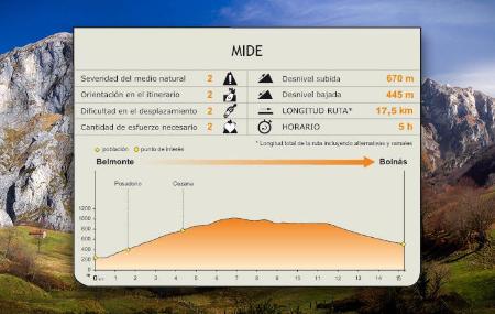

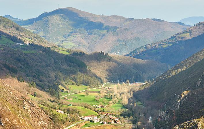
The GR is still linked to the historical communication routes that cross the council of Belmonte de Miranda, in this case the Camín Francés, used for the transport of gold-bearing material extracted in Roman times. Starting in Belmonte, the stage crosses the Sierra de Arceyo, passes through the foothills of the Sierra de Begega and ends in Boinás.
Belmonte/Balmonte - Bueinás 15,4
In Belmonte de Miranda, mining activity during the Roman Empire was concentrated in the Sierra de Begega, in the immediate vicinity of which were born centres dedicated to mining-related work. At this stage, the GR passes along the Camín Francés, which linked León with Asturias, and was used to transport gold-bearing material.
The Camín Francés crosses the municipality along the western ridge, and was also used by the "vaqueiros de alzada", who in the summer went to Somiedo. The route starts in Belmonte, capital of the council, crosses the Sierra de Arceyo and passes through the foothills of the Sierra de Begega, descending towards the valley of the river Cauxa, in the direction of the village of Boinás, the final destination of the stage.
Next to the signpost at the start of the stage in Belmonte, there are two alternatives for starting the route. One of the options continues along the AS-227 road, in the opposite direction to the village, passing through the industrial estate and taking a left turn on a steep ascent, in the direction of Posadorio (El Pousadoriu). The path passes over this village, without crossing it, and continues ascending towards the village of Cezana.
From Cezana, following the directional signs, the route follows a narrow stone and dirt track, climbing steeply along the Sierra de Arceyo, until it reaches the high area, where meadows and pastures predominate.
From this point, the path begins to descend towards Braña Extremera, between pastures and livestock sheds, with beautiful views of the Sierra de Begega and Peña El Castiellu (Carricedo), where the early medieval fortress of the Miranda territory was located (9th-12th centuries).
Between the 8th and 12th centuries, the administrative organisation divided the present-day council into two districts separated by the river Pigüeña: Miranda, on the left bank of the river, and Salcedo, on the right. Each of them had a fortification, from which the territory was controlled, and of which some remains are still preserved. The small size of the summit of Peña El Castiellu barely leaves room for a small tower, although the 970 metres of altitude allowed the whole of Miranda to be controlled.
Once past Las Brañas, following the directional signs, in the last stretch of the stage the route descends along a path until it reaches a crossroads, where the route continues along the path opposite until it reaches the road. Here we continue along the road in front, ignoring the roads to the right and left. We continue along this road until we reach a bend where we can see the Boinas gold mine pond on the right. Here we take a wide track that goes off to the left and heads towards the village of El Ferredal. On leaving the village, take a path that descends to Boinás, where the stage ends.
Alternative route 2,1
The second option, from the panel at the start of the stage, continues along the AS-227, crossing Belmonte, and continues along this road until it reaches Cezana.