
- Parres and Ribadesella Eastern Asturias
- Distance: 34,3 kms
- Difficulty: Half
- Altitude: 307.28 (maximum)
- Unevenness: 666.08 (rising)
- Mountain bike: 1 day
- Start point: Arriondas
- Tour type: Circular
- Layout of the route: Download kml

Arriondas - Colunga
Circular route that takes us to "La Cuevona", a natural cave hollowed out by the river that is the only access to the village of Cuevas in Arriondas.
Leave Arriondas in the direction of Colunga on the AS-260 and, once past San Andrés, join the AS-342. After passing Collía we take the AS-341, a road which we do not leave until we reach El Carmen. This section runs between the mountain ranges of Los Curones (on the left) and Monte Mouro (on the right). At the beginning you will have to climb up to the top of Las Coronas, which is the point on the route that requires the greatest physical effort. After a good descent surrounded by nature and livestock, and after passing Calabrez, the next climb begins, which is much gentler than the previous one. We are in the middle of the Cueva Rosa Partial Nature Reserve, an important karst complex that drains the waters of a large depression. The next descent means that the next slope can be negotiated almost without pedalling, reaching the village of El Carmen, where the first views of the Cantabrian Sea can be enjoyed.
Here we must turn off onto a local road in the direction of Soto and then towards Arduela to tackle a stretch between eucalyptus forests and meadows that will gradually reveal the town of Ribadesella in the background. This section is easy to cycle, except for 600 metres that must be climbed on foot, due to the steepness of the slope, to the church of San Salvador de Moro. This Romanesque church has recently been restored, and some of the architectural elements are preserved in the Archaeological Museum of Asturias. Inside the church there are some outstanding mural paintings.
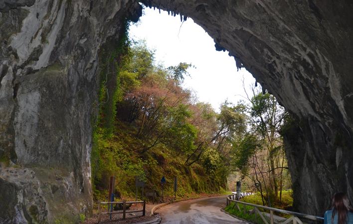
From this point to Arriondas, the whole route is easy to cycle and presents no difficulty at all. From the church, you start to descend to Nocéu, where you take the RS-3 to the village of Cuevas, but not before crossing La Cuevona (which gives its name to this route). For 300 meandering metres you can appreciate magnificent limestone formations, as well as the life linked to the darkness and the adjacent stream. Stalactites, stalagmites and lava flows are some of the formations which, due to their beauty and uniqueness, are sometimes called "La lengua del diablo" (The Devil's Tongue) or "Las barbas de Santiago" (Santiago's Beards).
Once you have crossed the village of Cuevas, you cross the fields along paths to reach a footbridge that crosses the river Sella and takes you to the N-634 road. On the way you will see the occasional sign for the mills route or PR.AS-58.1, a wonderful circular route through the area to do on foot.
You have to walk about 7 km along this national road, with a wide hard shoulder, passing through villages such as Fries or El Llano de Margolles until you reach Triongo.
In the latter town, and to avoid the traffic, we will cross another footbridge (with stairs at the beginning and end) over the river Sella. On the other side of the river, and once you reach the village of Cayarga y Fuentes, take the PR-1 road that runs along the left bank, passing through the village of Bode, and leads back to Arriondas, the end point of this route.
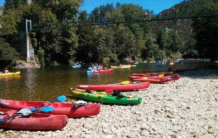
Although much could be said about the river Sella, it is navigable for the last 15 kilometres between Arriondas and Ribadesella. Numerous companies in the surrounding area organise descents down the river Sella in canoes or canoes, as this is one of the most popular adventure activities among visitors to the area.