

- Gozón Asturias Centre
- Distance: 34,9 kms
- Difficulty: Half
- Code: GR204 - Coastal Path E9
-
On foot:
8 h. 30 min.
Round trip
- Start point: Luanco Beach
- Layout of the route: Download kml
GR204 - Coastal path E9 - Stage 12 Low-difficulty path that runs through the municipality of Gozón. Most of it can be done by bicycle, at some points it does not follow the footpath, but there are other options for cycling. Declared Blue Trail

Luanco Beach - Nieva 34
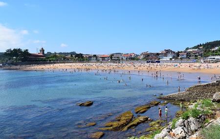
This route starts on the beach of Luanco, heading west and climbing slightly to reach Peroño, a terrace overlooking the sea. From this point there is an unbeatable view over Lluanco/Luanco and its fishing port. On days without haze it is possible to make out La Campa Torres and in the background the Picos de Europa.
When you reach a crossroads, turn right, cross the Santa Ana neighbourhood and begin a short descent that will take you to Moniello beach, which in turn serves as a tiny fishing port. Nearby there is a large rest area where you can recharge your batteries, and then continue along the edge of the cliffs until you reach Bañugues.
The route continues through Bañuges in the direction of Peñes. On the way there is the Llumeres recreational area, just above the old iron mine and the port that used to be a mineral wharf. The route continues in the direction of Viodo, descending towards its beaches, the first of which is sandy and the second of which is bowling.
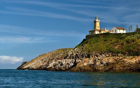
Shortly before reaching the second beach, a path begins that runs parallel to a small stream until it reaches the road to the Peñas lighthouse. This lighthouse was built at the end of the 19th century at the northernmost point of the Asturian coast and is the end of this route. The lighthouse house houses the Peñas Marine Environment Interpretation Centre.
The trail begins at the Peñas lighthouse, a magnificent building with a truncated pyramid-shaped tower built in the mid-19th century to replace the signalling that was previously done with bonfires. On the ground floor of the lighthouse is the Peñas Marine Environment Interpretation Centre, with several exhibition rooms.
If you go to the edge of the cliff and vertigo permits, you can admire the beautiful landscape of quartzite cliffs with a hundred-metre drop and Gaviera point, the northernmost point of the peninsula. If the emotion has been strong, you can always take advantage of one of the surrounding benches to sit down and fix your eyes on the island of La Herbosa and the sea birds that frequent it, such as seagulls, petrels, cormorants or gannets.
The path winds alongside heather and gorse bushes, characteristic of this siliceous soil, while leaving behind the Peñas lighthouse, which becomes smaller and smaller in the distance.
After 800 metres parallel to the AS-328 road, you descend to cross a wooden bridge before reaching the Casa Maravilla restaurant in the village of El Ferriru.
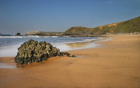
After crossing the road, the path descends to the Playa de Verdicio housing development, where the Tenrero or Verdicio beach is located. This beach is bordered by the river that meanders along a beautiful set of dunes. At the height of the Ramón bar, the path begins to climb up to the beaches of La Carniciega and Aguilera, both of which have golden sand and the former with a string of terraced dunes. Between the two beaches is a Celtic castro called "Los Garabetales", where you can still see the defensive moat.
After taking a break to contemplate the excellent views of Peñes and marvelling at the beauty of these beaches, we ascend until we reach the coastal ridge again. We then descend towards Puerto Llampero, a picturesque spot, the Molín del Puerto, which was affected by the floods of June 2010.
The path now climbs upwards to reach the level of the Cabo Negro lowlands once again, from where we can see the beaches of Portazuelos and La Riba de Pachón, both of which have black sand.
Moving towards the southwest, you reach a concrete structure. This is an industrial element of the cable car belonging to the steel company ENSIDESA, which used to dump slag at this point of Cabo Negro. Further on you reach the cliff overlooking Xagó beach. This is a very popular spot for paragliding enthusiasts who share their flight with seabirds.
Continue to the village of L'Otero and climb to the top of Xagó to descend along an asphalted track to the eucalyptus grove on Xagó beach. Here there is a rest area where you can have a snack before continuing your walk, parallel to the Xagó dunes and observing the two pools that serve as a refuge for waders.
In the southern part of the beach, the path climbs up to the village of Nieva, passing close to the 17th century chapel of San Juan. It then descends to a viewpoint on the cliff, from where you can see the long and beautiful Xagó beach and its system of dunes parallel to the beach.
The path continues in a north-westerly direction, along the coastal ridge of the Nieva peninsula, between meadows and patches of gorse and heather bushes. From here, you can see a bufón, which projects water in the form of a geyser if the sea conditions are favourable.
The path ends next to the Avilés lighthouse. It is worth stopping to contemplate the mouth of the Avilés estuary and the lighthouse with its pyramid-shaped tower dating from 1863. From this vantage point on the Nieva peninsula you can see the whole of the Avilés estuary and to the west El Espartal, Salinas and the coast of Castrillón as far as the island of La Deva.