
- Llanes and Cangas de Onís Eastern Asturias
- Distance: 21,4 kms
- Difficulty: Short
- Code: GR105.2 - Camín del Oriente
- On foot: 5 h. 30 min.
- Start point: Los Caleyos
- Tour type: Crossing
- Layout of the route: Download 2 etapa2
GR105.2 - Camín del Oriente - Stage 2

Los Caleyos - Corao 21,4
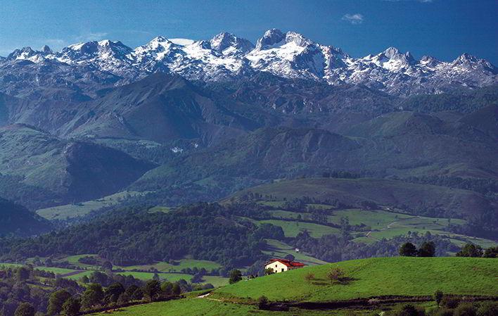
The first part of this stage runs through the valley of Ardisana, crossed by the river Riensena and flanked by the peaks of the Sierra del Hibeo and the foothills of Cerro Benzua. It starts where the previous route ended, in the village of Los Caleyos next to the church, which we leave on our left, crossing the village until we reach the exit where it turns sharply to the left, leaving the path that seems more normal and turning right again after a few metres to take the path, which climbs slightly between two houses, and which is flanked on the right by the last buildings in the village. A few metres further on there is a path that leads off to the left and heads towards the water tank, which we leave on the left. As we gain height, Los Caleyos appears below us and the silhouettes of the Picos de Europa begin to appear on the horizon, with the Naranjo de Bulnes towering above them all, and which will accompany us during this first part of the route.
Once past the water tank there is a turn-off to the right that increases the gradient of the path and along which the route runs, until we come to another turn-off. Here we leave the path we are on and take the path to the left, which leads off in front of us and whose ground is covered with a blanket of grass, and which heads west on the flat, ascending and ending in a meadow below the rocky slopes of the Peña Cuanda mountain. The route continues along the left side of the meadow until almost the end, where there is a passage between the stone wall and a sharp turn to the left to continue along a path that runs halfway up the slope to the west, next to a concrete post fence and heads towards the Robleu hut. Once there, we continue leaving it to the right, we reach a meadow, with a tree in the middle, which we cross until we find a path on the left, we continue in the same direction through the meadow, after crossing the path, always towards the pass that we see in front of us through a path, which is in the highest part of the meadow and which takes us to the pass, which at certain times of the year is completely fenced in with electric shepherds, but which allows us to pass through various portholes. At the end of the meadow there is another path that leads off to the left, and here we can choose between two options. The first is to descend through the meadow and head towards a track below Benzúa peak, which you can see in front of you, or take the path to the left and follow it to the track. Once there, turn right and continue past a fountain and then between two old stables (where the lintel of the door of the hut on the left is made of a curved beam, giving it a very interesting appearance), to descend along a concrete path that runs through the hamlet of Los Rabiaos, now abandoned.
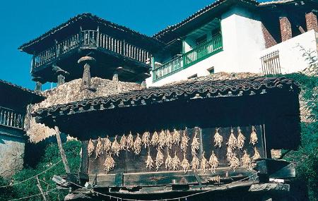
Shortly afterwards, we start a slight ascent that takes us next to a building that serves as shelter for a herd of goats, and where we turn first to the right and then to the left, to reach, after passing through areas where the trees flank the path, a meadow that overlooks the mountain range at the bottom of the valley, where this second stage takes place. Continuing along this path, you will begin to glimpse the houses of Ricaliente, which you will reach after continuing along the same path, which descends through vegetation. Ricaliente is crossed by two rivers, the Riensena and the Jo, and has the largest group of granaries in the eastern region of Asturias: a total of twenty-one. We pass near a house where a neighbour has several animals and invites us to see them with a sign that says "RIOCALIENTE tropical paradise in LLANES". After visiting the village and enjoying a good drink in the village bar, the route heads towards the river, which it does not cross, but continues to the right towards the west, taking the river to the left until it reaches a concrete track, which leads off to the right and runs through a beautiful meadow. Continuing along it and after a slight ascent, the concrete gives way to earth and leads into a eucalyptus grove, until we reach a meadow on the left and on a slope. Here we can see some tractor tracks on the left, which we do not follow, and to the right of the meadow a small eucalyptus grove. Continue along the track to the end of the meadow, where you leave the track and take the path to the left that turns west and climbs upwards, taking the meadow to the left.
After a short distance, the track flattens out and starts a slight descent. Ignoring the path that goes off to the left, the track ends and turns into a path, along which we must continue and crosses a stream to come out into an orchard where apple trees cover the ground, cross the meadow and take the track that comes out at the end of the meadow and leads us to a crossroads where we continue straight on, ignoring the one on the right. Shortly after, you will see the first houses of the village of Mestas, which you will reach in a short time. Once at the first houses, turn left to cross the village heading south next to the confluence of the rivers Riensena and Piedrahita.
The route crosses the village, with the river Riensena and the road clearly pointing south. Just after crossing the bridge we can see an old fountain on the right, now in disuse, and on the other side of the road, a path that enters a wood and climbs up through it, where at the first crossroads we should take the left-hand path that goes straight ahead and ignore the one on the right. Little by little you gain height and have a beautiful view of the village of Mestas, which you have just passed. In the middle of the forest there is a turn-off to the left and a path that goes flat. Do not take this path, but continue on the right and climb upwards until you reach the houses of Llumedián, next to a sloping meadow with many fruit trees. Once at the beginning of this meadow, leave the path and cross it towards the house you can see above you, where there is a path on the left that takes you into Llumedián. After passing the first two houses, the path turns right and leaves the village behind, with the deep valley of the river Piedrahita formed by the Sierra de la Cubeta and the Hibeo mountains in front of us.
It is at this point that the walker must be very careful, as it is necessary to leave the path and exit to the left in the middle of the meadow, as this has occupied the path, leaving the columns of the concrete light to the right, and enter the orchard, where at the end of it we find the path again, which for a short stretch becomes a bad path that reaches above a meadow with the road on the other side. Descending down to the meadow along a small embankment, the path first heads towards the road and then continues along the road to the right to reach the village of Telledo, after crossing the river. Cross the village and at the end of it take a track that runs with the river on the right and after twenty minutes of walking you come to a large brick stable on the right of the path, where it becomes a path. Continue in a westerly direction until you reach the confluence of two streams. Here you cross the stream on the left and take the path that comes out in front of you and takes the river to the right, which leads you uphill to the start of the Calzada Romana de Piedrahita, which is in perfect condition for a stretch of one and a half kilometres. It continues up the slopes of the hillside, gradually gaining height. The road runs between pines and bushes until it reaches a small hill, which gives us a break, and passes into the other valley where we can see a track that crosses the slope opposite.
Shortly after, it starts to climb again and you can see the perfect walls that were built to make the road, although it is somewhat destroyed in this section. You reach a small meadow to the right of the path, next to a solitary pine tree on the hillside. Here we must leave the path, which seems to continue, and turn right to reach the pass of Vega del Puerto, the boundary between the councils of Llanes and Cangas de Onís. From here you can see green meadows in the background, crossed by an asphalted track above a house, almost at the confluence of the two slopes.
From the pass there are two alternatives: the first is to turn slightly to the right and head towards the small oak grove we can see, to take the path that runs through it and descends to the bottom of the valley; the second is to cross the pass towards the bottom of the valley, but leaving the stream always on the left. With either of the two options you reach the beginning of the Piedrahita river, next to a beautiful hut located in a small meadow completely covered with large trees. Continue along the path, which crosses the river next to a water deposit where there is a tap, allowing you to quench your thirst. After a short while you will find the remains of the Roman road again, but this time you can only see the trace and the odd wall, and it heads towards the village of Cuerres that you can see ahead. The path on the left takes us, after taking the path on the right at the next crossroads, to the river, and runs along it for several metres, then comes out onto the asphalted track that leads under the village to Cuerres. Here we have no choice but to take the asphalted track, which ends at the Llenín road, next to the bridge, and which leads us to Llenín for about two kilometres.
From Llenín the view of the central and western massifs of the Picos de Europa is extraordinary, and we can also see the Cruz de Priena, along which this Camín del Oriente goes. The lands of the Gamonedos and the peaks of Cabezo Llorosos and Jascal can also be seen. There is a road between Llenín and Tárañu, but at the exit of the first village there is a track that goes off to the left and avoids the tarmac along this short uphill stretch towards the next village. Once in Tárañu we turn left, leaving the village on a wide track which, after the last few hamlets, climbs slowly and skirts the Iguedo hill, which is easy to see because of the repeater antenna on its summit. In this section we can see numerous Asturian mountains, well known in our particular world of mountaineers, such as Pierzu de Beleño, Mota Cetín, etc., and when the descent becomes definitive, the valley of the Chico river appears to the right, along which the road goes from Llabra (a village on the other side of the valley) to the pass of Ixena in the direction of Nueva (in the council of Llanes).
We continue along the track that takes us to the hamlet of Corau Castiellu, which has some fine examples of rural architecture, such as the manor house of the Soto-Labra family dating from 1763 with an annexed chapel in a state of ruin. The house is still usable and forms a magnificent ensemble.
A short road leads to Corao, crosses the main road and passes in front of the Frassinelli house, where the illustrious "German of Corao", Roberto Frassinelli y Burnitz, lived. The mansion, dating from the 17th century, has a garden and an estate which was the experimental orchard of the botanist Frassinelli, with various varieties of apples, medicinal plants, vegetables, etc. It suffered a fire which ruined a large part of its structure at the beginning of the 20th century.
Texts: Antonio Alba Moratilla