
- Case Asturias Centre
- Distance: 11,7 kms
- Difficulty: Short
- Code: PR60
- On foot: 3 h. 45 min.
- Start point: Tarna
- Tour type: Circular
- Layout of the route: Download kml
PR60

The village of Tarna is accessed via the AS-17 Avilés-Puerto de Tarna road just before starting the climb up to the pass.
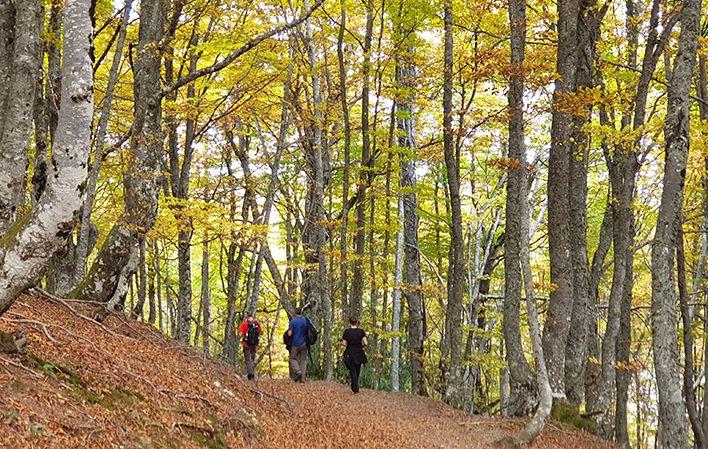
This route starts out from the village of Tarna, where you take a path to the right, paved with concrete in some sections, which heads uphill between stone walls to a beautiful beech forest. A little further on you come to a sharp bend to the left leading to the Terreros crossroads, where paths cross. At this point the trail branches into two: the left fork leads to Pyrenean oaks on Llano del Toro, and the right one to Tabayón Waterfall.
Taking the left fork, the trail continues for a fair stretch until reaching a small clearing, which you cross, climbing to the top. Further on, a narrow path leads into the woods, reaching Llanu'l Toru, as sort of hill in the middle of the beech wood.
From there you head back the same way to Terreros crossroads, where you now take what is the left fork leading to Mount Saperu. Further on, you cross Requexada Stream over a beautiful wooden bridge to walk in the shade of the trees without encountering any steep slopes.
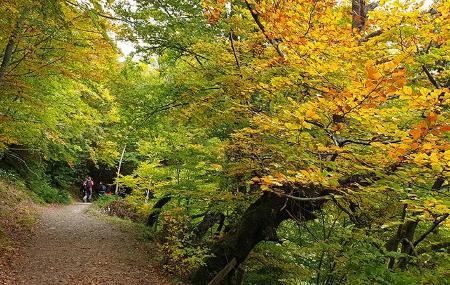
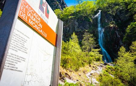
A little further on, the track ends at Los Arellales Spring, while the route continues skirting the hillside to reach a clearing from where the peaks of Cuetu Negru and Cantu'l Osu can be seen. Shortly after, you come to the area of level ground called La Campona, from where you soon reach Tabayón Waterfall. Though not much water flows over it, this is a singularly beautiful waterfall due to the height of the leap and the majesty of the surrounding beech wood. Crossing the high meadow and heading slightly downhill, you come to the River Mongallu, which you ford wherever you are best able to.
The trail then heads back to La Campona, where you take a path that will allow you to close the loop, instead of having to backtrack.
To do so, you take a blazed path, though less evidently marked at the beginning than the one that brought you up here. This runs below the high meadow, leading into the River Mongallu Valley below the slopes of Cuetu Negru.
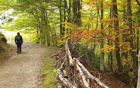
It soon becomes a wide path through the woods as it heads down into La Ablanosa Valley, where, in the middle of a small clearing in the woods - Majada Rebollau high meadow -, the trail turns sharply to the left, offering views of Cantu'l Osu. You cross the River Nalón over a sound bridge and the trail heads upwards for a short distance to reach the road to Tarna Pass. Just 20 metres further on, however, a path heads gently downhill to the right, between the river and the road. This path between farmland leads to the village of Tarna, coming out right at the entrance to the village, at the point where you began the route hours earlier.
Tarna - Tarna 11
Circular route from the village of Tarna passing by the Mongallu waterfall. The village of Tarna can be reached via the AS-17 Avilés-El Puerto (Puerto de Tarna) just before starting the ascent to the mountain pass.
This route starts in the village of Tarna (Caso), where we take a path to the right with a concrete road surface in some sections, and along which we ascend between stone walls, arriving at a beautiful beech forest.
A little further on, we come to a sharp bend to the left, and we are at the crossroads of Terreros, where there is a crossroads. At this point the path divides, the one on the left leads to the Rebollos de Llanu'l Toru and the one on the right to the Tabayón waterfall.
Taking the left fork, the path continues along a good path to a small clearing, cross it and head towards the highest part of the path. Later on, a narrow path leads us into the forest, and we reach the Llanu'l Toru, a kind of hill in the middle of the beech forest.
From here we must return along the same path to the crossroads of Terreros, where we now take the path to the left that takes us to Monte Saperu. Later, we cross the Requexada stream over a beautiful wooden bridge, and we will walk with the effect of the shade of the forest and without great unevenness.
A little further on, the track ends at the Arellales fountain, and the route continues along the slope until it reaches a clearing in the forest where you can see the peaks of Cuitu Negru and Cantu'l Osu. Shortly after, the esplanade of La Campona comes into view, from where the Mongallu waterfall is soon reached.
The waterfall, although with a low flow, is of singular beauty, due to the height of the waterfall and the majesty of the beech forest. Crossing the sheepfold and losing a little height, we approach the Mongallu River, which we cross wherever we can.
We return to La Campona, where we take a path that will allow us to close the circuit, instead of returning along the same route.
To do this we take a signposted path that is less obvious in the first few metres than the one we had taken up to here, and which goes under the meadows of the sheepfold and enters the valley of the Mongallu River, under the slopes of Cuitu Negru.
It soon becomes a wide path that crosses the forest in search of the bottom of the Ablanosa valley, and here, in the middle of a small clearing in the middle of the forest - the Rebollau sheepfold - the path turns sharply to the left and it is then that we can contemplate Cantu'l Osu.
We cross the river Nalón over a good bridge, and the path climbs a few metres and comes out onto the road to El Puerto (Puerto de Tarna), but just 20 metres further on a path descends slightly to the right, between the river and the road. This path, between farms, takes us to the village of Tarna, coming out just at the entrance to the village, at the point where we had started the route a few hours earlier.