
- Aller Asturias Centre
- Distance: 17,9 kms
- Difficulty: High
- Code: PR31
-
On foot:
6 h. 30 min.
One way
- Start point: El Pino
- Tour type: One way
- Layout of the route: Download kml
A very difficult hike through the heart of the borough of Aller between El Pino and La Paraya

Access to the starting point is via the AS-253, in El Pino.
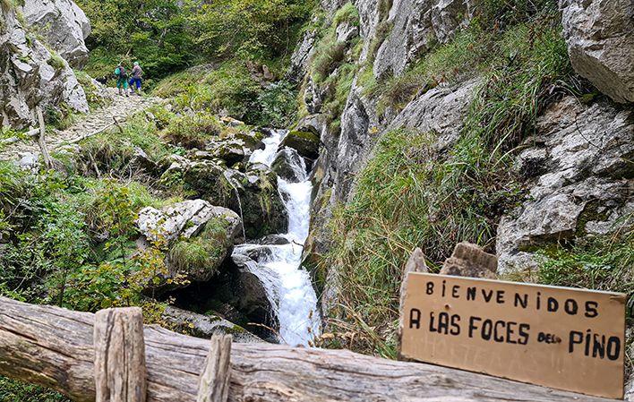
The trail starts in the village of El Pino, from where a track heads gently uphill leading to Peón Mill, a former mill now reconverted into a trout farm. At this point, take the track that crosses the river and heads upwards towards El Pino Gorges, through fields and areas abundant in native tree species.
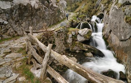
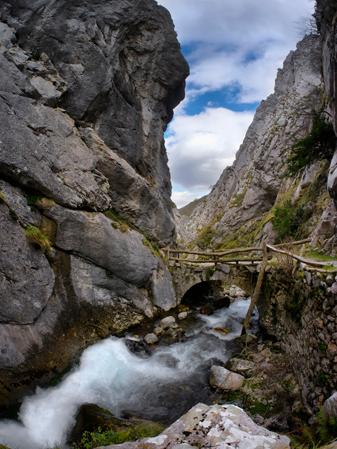
Immediately after, you will come to a spring on your right, next to which is a path leading to a crossroads by the remains of an old hydroelectric power station. Take the path to the left here, crossing the river again over a stone bridge. This gorge is noted for its wild beauty.
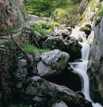
At this point, you should take the track on the left which heads uphill to the south until leaving the gorges, where the track becomes a stone path carved into the rock.
At the end of the gorges, the landscape changes and the high mountain pastures appear.
This is where you take the path that bears left and, without crossing the river, head uphill for a short distance before taking the turning on the right leading to Caniecha and Vegarada. It is at this turning where you must choose which path to follow, as the one to the right leads to a place called La Cabritera, dotted with shrubland and broom shaded by a magnificent beech wood.
La Cabritera leads to Caniecha (Caniella), a high mountain meadow with two huts and a spring where you can rest. After passing the huts, a short climb takes you up Caniella Hill. This place is a beautiful vantage point offering views of peaks such as El Estobín, Puerta Faro, Redonda Crag, among others.
From here, head up to the nearby pass of the same name, which also offers beautiful views. The trail continues south towards La Mamergona, a flat area of pastures where there is a small shelter with a tap to get water.
Always heading south, after a short climb you come to El Cotarón, whose pass offers innumerable panoramic views. Back on the trail, another downhill climb between shrub and broom leads to Vega de la Reina. This is the highest point on the trail, right on the border between Asturias and León. You only need to take the track that heads north, leading down between the mountain meadows of Brañuela and Carbayalín to come to the village of Río Aller. From here the route continues along the road through the River Aller Gorges and ends in Paraya.
El Pino - La Paraya
17
One way
The route starts in the village of El Pino, from where a gently ascending track leads us to the Molino de Peón, an old mill that has been restored as a trout farm. At this point we take the track that crosses the river and heads upwards towards the Foces del Pino, through meadows and areas with abundant native trees.
Immediately afterwards, we will find a fountain on our right, and right next to it a path leads us to a crossroads, which is next to the remains of an old hydroelectric power station. Here we take the path to the left, crossing the river again over a stone bridge. This gorge is remarkable for its wild beauty.
At this point, take the track on the left that climbs upwards towards the south, until you come out of the gorges, where the track turns into a stone path carved into the rock.
At the end of the foces, the landscape changes and the high mountain pastures appear.
Here we must take the path that turns to the left and, without crossing the river, climbs upwards and, after a short stretch, takes the turning to the right that leads to Caniecha and Vegarada. It is at this turn-off that we must choose which route we want to take, given that on the right the path goes to a place called La Cabritera, dotted with broom and broom and shaded by a magnificent beech forest.
La Cabritera leads us to Caniecha or Caniella, a sheepfold with two huts and a spring where we can rest. After passing the huts, we reach the pass of Caniella, which can be reached by climbing a short distance. This place is a beautiful vantage point from where you can see peaks such as Estobín, Puerta Faro, Peña Redonda, etc.
From here we must ascend to the nearby pass of the same name, with beautiful panoramic views. Our route continues south towards Mamergona, an esplanade of pastures where there is a small refuge with a tap where we can get water.
Continuing southwards and after a short climb, we reach Cotarón, whose pass offers innumerable panoramic views. Once again, another descent through broom and broom trees takes us to Vega de la Reina. We are now at the highest point of the route, and have finally reached the border between Asturias and León. Now all we have to do is take the track that, heading north, descends between the sheepfolds of Brañuela and Carbayalín. This brings us to the village of Ruayer. From here we continue along the road, passing through the Hoces del Río Aller, and finishing the route at La Paraya.
It could be done by mountain bike, between El Pino and Foces de El Pino and also between the stretch that goes from Ruayer to Caniecha. There are people who enter through Ruayer, climb up to Caniecha and descend from there to El Pino crossing Foces de El Pino (between Caniecha and Foces de El Pino it is all mountain path, to descend yes, but to climb up is complicated).
- Cannot be done with a pushchair/stroller.
- It can be done by mountain bike (high difficulty). Between El Pino and Foces de El Pino and also between Ruayer and Caniecha.