
- Cangas del Narcea Western Asturias
- Distance: 8,5 kms
- Difficulty: Half
- Code: PR132
- Altitude: 639 m.
- Unevenness: 64 m.
-
On foot:
Section 1:
2 h. 30 min.
Section 2:
2 h.
Section 3:
1 h.
2 min.
- Start point: Mual
- Tour type: Circular
- Layout of the route: Download kml, Download gpx
PR132
The start of the trail is accessed via the AS-348 road from Cangas del Narcea to Degaña, taking the AS-348 in Ventanueva which leads to Ibias via Connio Pass. In barely a kilometre you come to Moal, the starting point of this trail and entrance to Muniellos Nature Reserve.
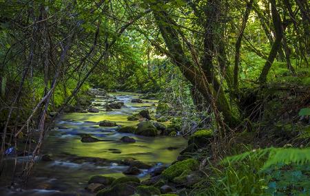
The trail described here is an easy hike in the vicinity of Muniellos Nature Park, in Las Fuentes del Narcea, Degaña e Ibias Nature Park. The beginning of the trail is located in the village of Moal, where you take a concrete path running between the houses which you should follow right to the end of the route. In the vicinity of Moal, there is a chestnut wood on the other side of the river where you can see several "corripas", circular constructions with a stone enclosure used to store spiny chestnut burrs and let them "cure" until they give up their fruit more easily.
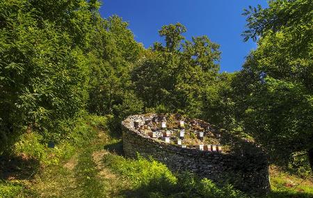
After leaving the village, the trail runs parallel to the River Muniellos, crossing the river meadows and leaving the chestnut woods behind. The route continues among Pyrenean oak and beech woods which cover the slopes on both sides. "Cortinos" can be seen all along the trail. These are circular stone constructions whose mission is to protect the beehives they house from being raided by bears.
The route continues along the main track, without taking any path that may branch off from it, until you reach the barrier impeding entry to Muniellos Nature Reserve, the veritable jewel of Asturias' natural heritage that shelters emblematic species such as the brown bear and the Cantabrian capercaillie. To enter the reserve, you need to apply for a permit issued by the ministry responsible for protected natural areas, as access is restricted and limited to a maximum of twenty visitors a day. Take the path to the left which continues uphill, first among oak and chestnut trees and then through a beautiful beech wood.
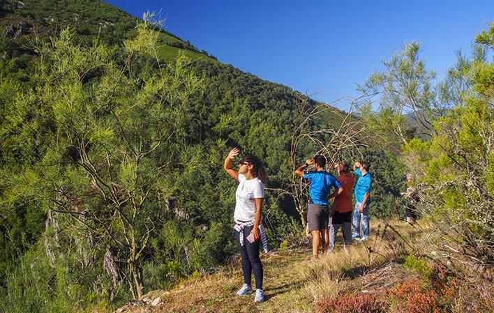
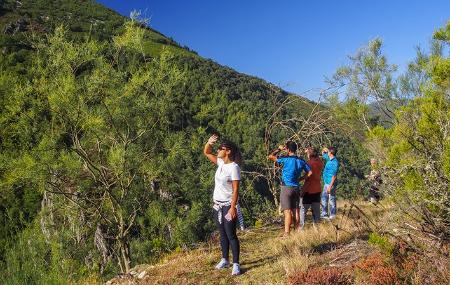
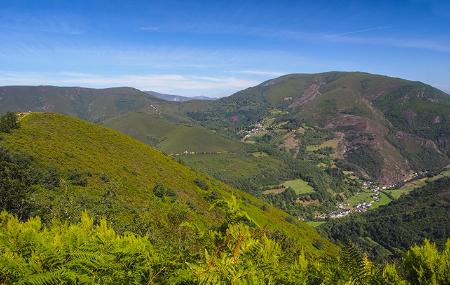
After passing through the beech wood, the trail continues uphill towards Montecín Scenic Balcony, which can be seen up ahead. From the scenic balcony there are views of the village of Moal, Connio Pass and the lower part of Muniellos Nature Reserve-Biosphere Reserve.
Back on the main track, the trail continues to the left through a beech wood until reaching the crossroads called Colláu de Moncóu. You should take the left turning that heads steeply downhill to the same track that you used on the climb up, which takes you back to Moal.
Mual - Mual 8
Hidden among the mountains, at the bottom of the Muniellos river valley, at the gates of the Integral Biological Reserve of the same name, is Mual, winner of the 2018 "Exemplary Village of Asturias" award.
This route through bear lands shows us the adaptation of human beings to this environment throughout history, a story of lumberjacks who maintained a forest of extraordinary quality thanks to responsible logging that allows us to continue enjoying forest masses where the sessile oak and the melojo, together with the beech, are the kings of the place.
The presence of the bear is shown to us, in addition to the tracks or droppings that we can find if we pay attention to the ground, by the existence of "cortines", stone constructions to protect the bee apiaries from the attack of these bee-eaters.
This circular route starts initially in the village of Mual, but you can also leave your car in a car park near the sports centre and the church, about 600 metres from the entrance to the village, crossing the river on the left, and start walking there.
The initial part is a forest track with a very slight slope that crosses the forest parallel to the river. After reaching the first kilometre, we come to a crossroads, where we take the one on the left, as the other one will be the one we will use on the way back. As you go on, the gradient becomes steeper and steeper, at least for the next kilometre and a half.
After 2.5 kilometres, we come to another crossroads, where we opt for the one on the right to get to the highest part of the route with the best views. We must always keep to the right, as there are some paths through the bushes that can lead to confusion and divert us from the route.
When we reach kilometre 4, we have the possibility of following the path that will take us to the Montecín viewpoint, from where we can contemplate the magnificent views of the valley, the village of Mual and the entrance to Munieḷḷos.
We retrace our steps for a few metres to rejoin the main path to the right; from this point onwards, the descent begins and we enter the wooded area once again. The path continues along the track until you have completed 8 kilometres of your route, where you come to the first crossroads again. We continue to the left along the same stretch as at the beginning of the route, which will take us back to Mual.
Mual - Las Tablizas - Mual 5,46
This section must be considered as a walk that begins with a route through the village of Mual, located about 20 minutes by car from the capital of this council in the southwest of Asturias, which stretches out in a narrow valley, and ends up merging in an embrace with the Munieḷḷos Forest.
After passing Mual, the walk runs parallel to the Muniellos River and continues to the Muniellos Integral Reserve, where we find an old hydroelectric power station.
The last few metres of the route take us to the Munieḷḷos Visitor Reception Centre, which is the gateway to the Muniellos Integral Nature Reserve.