

- San Tirso de Abres Western Asturias
- Distance: 7 kms
- Difficulty: Half
- Code: PR300
- Altitude: 100
- Unevenness: 65
-
On foot:
1 h. 30 min.
One way
- Start point: As Veigas
- Tour type: One way
- Layout of the route: Download kml, Download gpx
PR300


A simple walk to discover the secrets of the riverside forest. Upstream, we follow in the wake of the salmon, which guide us along the path of the Eo on the box of an old railway. If we are lucky we will be able to see them jumping, going up the crystalline waters at the old spawning station.
Alders, ashes, willows and royal ferns dominate the leafy banks of the Eo, reflecting in its waters like a Narcissus, enjoying themselves and becoming the perfect frame for our photographs.
The branches serve as perches for the beautiful kingfishers to fish from, for some cormorants to rest and for all of them to contemplate the leaps of the salmon in the ski lifts as well as the otters looking for their prey.
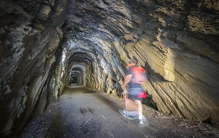
We would hardly notice the human intervention if it were not for the perfection of the path along which we walk or roll, for the tunnels through which the old train used to pass or for the bridges that helped it to avoid the overpasses over the Eo.
As Veigas - Prado 7
The route starts at the old train station As Veigas, in the neighbouring village of San Tiso. The route follows an old railway track to the border with Galicia, south of the village of Prado. We leave the village along the old track and about 300 metres from the station we will find a tunnel, which we have to cross to access the river Eo, which will accompany us along the route.
After the first kilometre and a half of the route, we will cross the N-640 road: at this point, be very careful before crossing, after 700 metres, we will find another tunnel, at the exit of which we will see a dam in the river.
After another half kilometre, we come to a fork, where we take the path to the left. After approximately 3 kilometres, we come to a metal bridge, which allows us to cross the Eo River to continue our route.
When we have walked about 4.4 kilometres from the start, we can approach the river to see a dam with a scale of troughs. The ladder is a construction that is made in some river dams and is used to allow fish, such as salmon in their migratory season, to pass through.
Some 300 metres further on, we come to another tunnel, which allows us to cross the road underneath, and the following kilometre we come to the fourth and last tunnel, which will take us to the end of the route.
When we reach the end of our route, kilometre 7, the path ends at the point where the road and the path cross.