Bulnes by the Canal del Texu

- Distance: 7.4 kms
- Difficulty: Moderate
- Cumulative difference in altitude: +537 m
- Cumulative difference in altitude: -537 m
- Maximum altitude: 700 m
- Minimum altitude: 233 m
- IBP index: 55
- Modality: Hikers
- Type of route: Round trip
- Route type: Mountain
- Return by Train: No
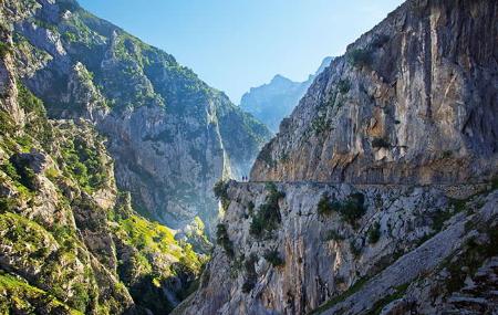
The route to Bulnes along the Canal del Texu is one of the most emblematic accesses to a village that was, until a few decades ago, one of the most isolated in Asturias. The route goes up a narrow, steep gorge that links Poncebos with Bulnes, in the heart of the Picos de Europa National Park. It is a short but intense climb, which requires constant attention and respect for the mountain.
The route starts in the vicinity of Poncebos, next to the starting point of the famous Ruta del Cares. After crossing the La Jaya bridge, the path enters the Canal del Texu, a gorge squeezed between high limestone walls. From the first steps, the verticality of the surroundings and the sound of the river Bulnes in the background accompany the walker as the path zigzags upwards along a route carved directly into the rock.
Along the way, the vegetation clings to the cliffs: holm oaks hanging from the cliffs, foxgloves (Digitalis parviflora) - a species endemic to the Cantabrian mountain range - and small mountain snails that carpet the damp rock, reminding us that this channel, despite its ruggedness, is home to a unique biodiversity. The terrain is uneven, with live rock and areas polished by erosion, which makes it slippery when it rains. It is therefore recommended to avoid the route in bad weather and is not suitable for small children or people with no experience in mountain hiking.
The ascent passes over the Zardu Bridge and further on by the turnoff to the Bulnes funicular railway, a mechanical option that links the base of the valley with the village in just a few minutes and which can also be used to descend. Shortly afterwards, you reach the village of Bulnes, one of the most picturesque enclaves in Asturias, conserving its traditional architecture with stone houses and cobbled streets. At the entrance is the Capilla de las Nieves chapel and the Fuente de la Villa fountain, an ideal place to refresh yourself.
From Bulnes a path leads up to the Picu Urriellu viewpoint, also known as the Naranjo de Bulnes viewpoint, one of the most iconic panoramic views of the Picos de Europa. On clear days, the silhouette of the Urriellu is clearly silhouetted against the sky, making this hike an unforgettable experience.
The return journey can be made by the same route or, if you prefer, by funicular railway. In total, there are just over 3 kilometres of ascent, with an accumulated difference in altitude of some 400 metres. A short but demanding route that connects landscape, history and isolation, and allows you to reach one of the best known and most emblematic mountain villages in the Cantabrian mountain range. IMPORTANT!!! Responsible access: use of public transport during high season.
In high season (Easter, May Bridge and summer), the Principality of Asturias activates a special public transport plan to facilitate access to the Cares Route, Bulnes, Tielve, Sotres and Pandébano, with departures from Arenas de Cabrales. The aim is to avoid overcrowding at busy points with few parking spaces.
Buses leave from Arenas with intermediate stops in Poncebos, and frequencies practically every hour from 8:00 to 21:00.
Tickets can be bought in advance at www.alsa.es or on the bus itself if there are still places available.
Visitor parking is limited, especially in Poncebos and Pandébano. It is advisable to use the areas provided in Arenas and avoid parking outside the marked areas.
To enjoy the route to Bulnes in a safe and sustainable way, especially in summer, it is highly recommended to use public transport.
- It runs partly through the National Park and Biosphere Reserve of Picos de Europa, as well as through the ZEC and ZEPA Picos de Europa (Asturias) of the Natura 2000 Network.
- The route runs entirely along part of the GR-202.
Basic tips before going into the mountains
- If you go with a dog, always keep it on a leash.
- Avoid approaching livestock.
- If you find mastiffs protecting livestock, do not approach them, do not pet them and do not feed them. Do not allow them to follow you or stray from their herd. They are working.
- Don't leave a trail. Collect all your waste, including organic waste. Nature is not a dumping ground.
- Act with prudence. Plan your route well, take everything you need and make sure it is adapted to your physical capacity.