The Cares Route

- Poncebos, Cain Eastern Asturias
- Distance: 22.1 kms
- Difficulty: Very difficult
- Cumulative difference in altitude: +831 m
- Cumulative difference in altitude: -831 m
- Maximum altitude: 532 m
- Minimum altitude: 210 m
- IBP index: 86
- Modality: Mountaineers
- Type of route: Round trip
- Route type: Mountain
- Return by Train: No
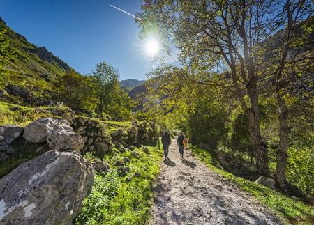
The Cares Route, between Poncebos (Asturias) and Caín (León), is one of the most emblematic hiking routes in Spain. Along its 11 kilometres (22 km round trip), it runs through a breathtaking gorge carved out by the Cares River, in the heart of the Picos de Europa National Park. A spectacular route that combines history, human effort, geology and landscape.
The trail starts next to the Bulnes Funicular car park, in Poncebos. After crossing a small bridge, the route gains height between limestone outcrops for the first two kilometres. From there, the perspective widens: the Cares meanders at the bottom of the abyss, flanked by towering limestone walls. The path, dug directly into the rock in many sections, is barely a metre and a half wide and runs without any great unevenness, but is always exposed, which demands attention and respect for the environment.
A titanic work that gave rise to the path
What is now an iconic hiking route, trodden by thousands of people every year, was originally a feat of hydraulic engineering. In 1916, construction began on a canal of almost 9.5 km between Cain and Camarmeña, with the aim of transporting water to the Poncebos hydroelectric power station. The work took six years to complete and posed a formidable human and technical challenge: more than 5,500 metres of tunnels, dozens of workers sleeping in caves and huts, transport by barge across the canal or by horse and endless days with hand tools and gunpowder fuses.
One of the most memorable episodes was that of 400 workers isolated by snow in Cain, who crossed the mountain by night and on foot in search of supplies, overcoming avalanches and vertical slopes until they reached Los Collaos, near Poncebos. Their effort is an example of the heroic dimension of this undertaking.
Completed in 1921, the canal transformed the economy and way of life of the area. But it also altered its ecology: with its opening, the largest walnut forest in Europe, which descended from the Canal de Trea to the waters of the Cares, was cut down. The trees were cut down and dragged by the river itself to the villages.
The birth of the current path
The canal needed constant maintenance, which led to the construction of the path we know today as the Cares Route in 1945. Barely 1.5 metres wide, dug into the edge of the cliff, this service path replaced the most dangerous and narrow passages with a safe, though breathtaking, route. Since then, it has established itself as one of the great mountain roads of the peninsula.
Today, the route includes tunnels with open windows to the abysses, footbridges and bridges such as Bolín or Los Rebecos, and allows you to reach Caín de Valdeón, a small enclave in León surrounded by peaks. The return journey can be made along the same route or, in one direction only, by hiring specialised 4x4 transport services, which offer interpretative routes through the massif.
Responsible access: public transport at certain times of the year
At certain times of the year, a special access regulation system is activated for the Cares Route, the Bulnes funicular railway and other sites in the Picos de Europa National Park, such as Tielve, Sotres or Collado Pandébano.
In 2026, the special transport plan will operate from 28 to 31 March, from 1 to 5 April, from 1 to 3 May, every weekend in May and from 1 June to 12 October.
Buses depart from Arenas and arrive at Poncebos, where you can start the Cares Route, take the funicular to Bulnes or change to continue to Tielve or Sotres. Departures are approximately every hour between 8:00 and 13:00 and between 17:00 and 19:00, stopping at the Ovar car park. The last service of the day leaves Sotres at 20:00, arriving in Arenas at around 21:00.
Tickets should be purchased in advance through the ALSAS website , whichopens in a new tab; only if there are still places available can they be purchased on the bus itself. The journey between Arenas and Poncebos, the starting point of the Cares Route and access to the Bulnes funicular, costs €1.55 each way (€3.10 return). The journey between Arenas and Tielve or Sotres costs €2.60 each way (€5 return).
From 17 July to 23 August there is a shuttle service from Cangas de Onís to Poncebos and Cain, with return connections, allowing those who wish to do the Cares Route in one direction only.
From Cangas de Onís to Poncebos there are departures at 13:50 (S and D) and 18:50 (F-S-S-D-L), returning from Poncebos at 16:30 (S and D) and 20:00 (F-S-S-D-L). From Cangas de Onís to Caín there are departures at 10:15 (S-S-S-D-L) and 17:15 (S and D), returning from Caín at 12:00 (S and D) and 17:00 (F-S-S-D-L).
This system contributes to a more orderly, safe and sustainable visit to one of the most frequented areas of the Picos de Europa National Park, favouring the conservation of its natural environment and landscape.
- It is not forbidden to take children, but it is recommended that they are over 12 years of age. In the case of younger children, they should always be held by the hand, placing them on the inner part of the path.
- It runs through the Picos de Europa National Park and Biosphere Reserve, as well as the Picos de Europa SAC and SPA (Asturias) of the Natura 2000 Network.
- PR-AS 229
- This route partially coincides with the GR-202.
Basic tips before going into the mountains
- If you go with a dog, always keep it on a leash.
- Avoid approaching livestock.
- If you find mastiffs protecting livestock, do not approach them, do not pet them and do not feed them. Do not allow them to follow you or stray from their herd. They are working.
- Don't leave a trail. Collect all your waste, including organic waste. Nature is not a dumping ground.
- Act with prudence. Plan your route well, take everything you need and make sure it is adapted to your physical capacity.