
Cape Busto

- Bustu Western Asturias
- Distance: 7.61 kms
- Difficulty: Easy
- Cumulative difference in altitude: +376 m
- Cumulative difference in altitude: -376 m
- Maximum altitude: 118 m
- Minimum altitude: 2 m
- IBP index: 29
- Modality: Families
- Type of route: Circular
- Route type: Coast
- Return by Train: No
Its cliffs and paths have witnessed the passage of time, revealing in archaeological excavations the remains of the first human occupations in the north of Spain. An unforgettable journey through nature and history.
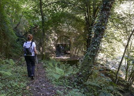
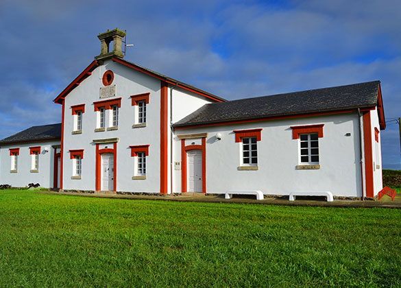
The route to Cape Busto begins at the chapel of San Bartolomé, in the village of Bustu, from where we head towards the old schools, a stone building constructed in 1901, which currently houses the Eduardo Pérez de la Fanosa library.
From here, we take a path that leads us to the Imeas viewpoint, a spectacular natural balcony with views of the village of Cueva, its beach and the mouth of the river Esva.
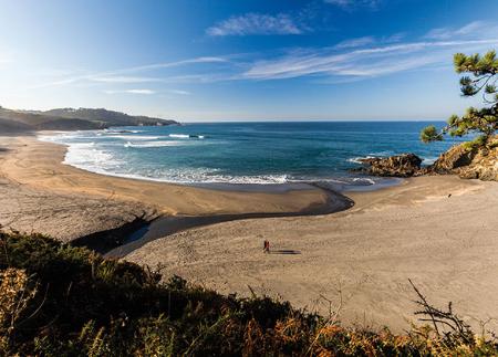
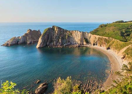
The route then descends through pine woods towards Bozo beach, a corner sheltered from the wind, with imposing vertical walls overlooking the sea and a cave through which the water enters at high tide. Those who wish can descend to the beach to explore this unique enclave, while those who prefer to avoid the descent can continue directly along the main route.
From this point, the path continues through pine woods and cornfields to the Monte del Cabo viewpoint, where there is a rest area with tables and benches, and from where you can get a new perspective of Bozo beach. From here, the path skirts the coastline of Cape Busto, passing by the Faro de Busto recreational area and the Busto lighthouse itself, one of the most emblematic landmarks along the route.
The viewpoint at Cape Busto, the closest to the lighthouse, offers impressive views of the islands of La Moura and Las Mouchas, enhancing the rugged beauty of the western coast of Asturias.
We continue on to the Punta de Arenosos viewpoint, from where we can see the Serrón beach, the island of El Salto and the beach of Las Barchinas. This stretch, flanked by cypress trees, leads us back to the village of Bustu, where the route ends.
Beyond its spectacular coastal landscape, Cabo Busto hides one of the most important archaeological sites on the Cantabrian coast. Lithic tools carved from quartzite have been found in this area, such as hand axes (bifaces), raederas and picks, which confirm the presence of the first hominids to inhabit the north of the peninsula. These tools, attributed to Acheulean technology, were used more than 300,000 years ago by Homo heidelbergensis, an ancestor of the Neanderthals.
Archaeological studies have identified two occupation levels at Cabo Busto, separated by more than 200,000 years. At the oldest level, groups of Homo heidelbergensis used this territory as a hunting and supply area, while at a higher level, tools used by Neanderthals around 100,000 years ago have been found. These findings have turned the Valdés coastal plain into one of the most important Palaeolithic sites, consolidating Cabo Busto as an enclave of reference for understanding the first human occupations in northern Spain.
The combination of cliffs, viewpoints, beaches and unique archaeological remains makes the route to Cabo Busto an unforgettable experience, where nature and history intertwine to reveal a fascinating past.
- It runs through the Cabo Busto-Lluanco/Luanco SAC of the Natura 2000 Network.
- PR-AS 004
- Road sections
Basic tips before going into the mountains
- If you go with a dog, always keep it on a leash.
- Avoid approaching livestock.
- If you find mastiffs protecting livestock, do not approach them, do not pet them and do not feed them. Do not allow them to follow you or stray from their herd. They are working.
- Don't leave a trail. Collect all your waste, including organic waste. Nature is not a dumping ground.
- Act with prudence. Plan your route well, take everything you need and make sure it is adapted to your physical capacity.


