Mina As Talladas Route - "Route with art".
, in Santa Eulalia de Oscos, is a walk through the history and memory of the Enlightenment. From the village, the trail leads to the Museum of the Birthplace of the Marquis of Sargadelos, a key figure of the Enlightenment, promoter of one of the first cast iron and earthenware factories in Spain. After crossing forests and hamlets, the path leads to the mouth of As Talladas, a witness to the mining activity in the area.")
- Santalla, Ferreirela de Riba, Ferreirela de Baxo, Caraduxe Western Asturias
- Distance: 13.5 kms
- Difficulty: Moderate
- Cumulative difference in altitude: +688 m
- Cumulative difference in altitude: -688 m
- Maximum altitude: 670 m
- Minimum altitude: 393 m
- IBP index: 62
- Modality: Hikers
- Type of route: Circular
- Route type: Themed
- Return by Train: No
From the village, the path leads to the Museo Casa Natal del Marqués de Sargadelos, a key figure of the Enlightenment, promoter of one of the first cast iron and earthenware factories in Spain. After crossing forests and hamlets, the path leads to the mouth of As Talladas, a witness to the mining activity in the area.
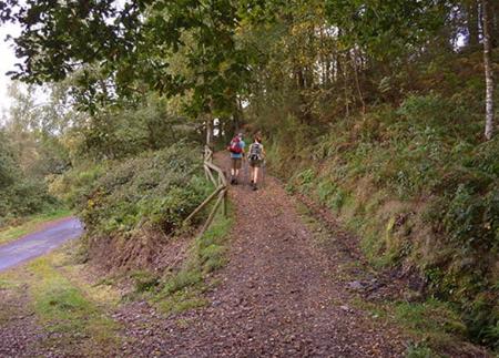
This route, which shares sections with the PR-AS 119 and the GR-109, starts in Santalla square and descends towards the lower part of the village, entering a beautiful native forest. The initial route conveys a sense of calm and connection with nature, guiding the walker first to Ferreirela de Riba and then to Ferreirela de Baxo, where it is essential to make a stop at the Museo Casa Natal del Marqués de Sargadelos, an enclave of great historical and cultural value. This first part of the route, like the last part, is by road, so, although traffic is scarce, it is advisable to take extreme precautions and respect traffic regulations.
Along this stretch, from Santalla to Ferreira, thirteen works of art from different disciplines such as painting, sculpture and iron have been installed. This artistic project, which involves both local and national artists, seeks to revitalise the rural environment through the integration of art in the landscape, revaluing its cultural and natural identity. The pieces have been designed with environmentally friendly materials, achieving a harmonious fusion with the surroundings.
From Ferreirela de Baxo, the path descends towards the river Agüeira and, following its course, reaches As Barreiras, where the waters of the river Vilanova join the Agüeira, creating a river landscape of great beauty. Shortly after, we reach Ferreira, a picturesque village ideal for a leisurely stroll. Here we cross the river Agüeira over a stone bridge next to the Ferreira recreational area, a perfect place to take a break.
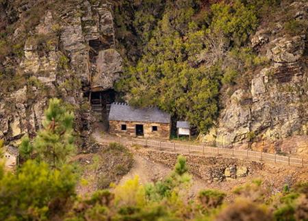
The route continues with a moderate ascent to As Talladas and then to the Carmina Mine, a mining operation active in the 50s and 60s, where silver, zinc and lead were extracted.
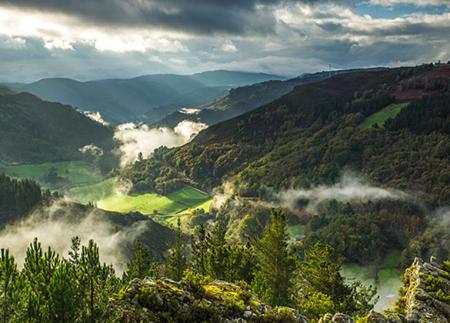
From here, we start our return along a path that runs halfway up the slope, offering spectacular views of the valley. This section is particularly picturesque, allowing us to contemplate the immensity of the landscape framed by mountains and forests.
The route then takes us to Caraduxe and back to Ferreirela de Riba, to finally return to Santalla. This route combines history, art, nature and industrial heritage, offering an unforgettable itinerary within the incomparable environment of the Biosphere Reserve Río Eo, Oscos e Terras do Burón.
- It runs through the Biosphere Reserve Río Eo, Oscos e Terras do Burón, as well as through the ZEC Cuenca del Agüeira of the Natura 2000 Network.
- PR-AS 203
- Partially coinciding with the PR-AS 119 and GR-109.
- Road sections
- Stony path sections
Basic tips before going into the mountains
- If you go with a dog, always keep it on a leash.
- Avoid approaching livestock.
- If you find mastiffs protecting livestock, do not approach them, do not pet them and do not feed them. Do not allow them to follow you or stray from their herd. They are working.
- Don't leave a trail. Collect all your waste, including organic waste. Nature is not a dumping ground.
- Act with prudence. Plan your route well, take everything you need and make sure it is adapted to your physical capacity.