Sierra del Aramo: La Xistra Peak-Santiago Peak-Rasón Peak-Barba Peak

- Distance: 9.87 kms
- Difficulty: Moderate
- Cumulative difference in altitude: +314 m
- Cumulative difference in altitude: -314 m
- Maximum altitude: 1726 m
- Minimum altitude: 1534 m
- IBP index: 54
- Modality: Hikers
- Type of route: Circular
- Route type: Mountain
- Return by Train: No
The route links peaks, lakes and high pastures, offering spectacular panoramic views of the valleys of Riosa, Quirós and Teverga. An unmarked route, suitable only for experienced and well-equipped hikers.
The route starts at Collado Tresnona, where there is a small parking area. From this point, a gradual ascent begins towards Pico La Xistra (1765 m), one of the most emblematic peaks in the council of Riosa. During this ascent, the landscape opens up towards the clear slopes of the Aramo, with spectacular views that increase as the altitude rises.
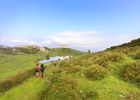
Once La Xistra is crowned, the route follows the ridge towards Pico Santiago, another important landmark in the sierra. The path is clear and well marked, allowing you to advance comfortably while enjoying the views over the Riosa valley. The subsequent descent leads to the small lake Fondo la Vega, a haven of water in the middle of the mountain surrounded by meadows where livestock usually graze.
The next peak on the route is Pico Rasón, which stands out for its wide panoramic views towards Quirós and Teverga, and on clear days even towards the Picos de Europa. From here, the path crosses areas of grassland and low scrubland in the direction of Pico Carba, from where the more rugged profile of the Aramo can be seen.
The route continues towards Pico Cuadrazales, where the terrain becomes more rocky and limestone, showing the harshness and beauty of this mountain range. We then reach Pico Barriscal, an elevation with interesting geological formations and depressions shaped by erosion.
The route ends with the Barrosu and Llanón peaks, which link up with the Cueva lake, an ideal place to take a break before returning. The final section, which descends gently, brings the hiker back to Collado Tresnona.
This high mountain circular route covers some of the most representative peaks of the Aramo, combining spectacular landscapes, geological elements of interest and a remarkable natural wealth. It should be noted that the route is not signposted and lacks water sources, so it is essential to be well prepared, carry sufficient hydration and have mountain experience.
Basic tips before going into the mountains
- If you go with a dog, always keep it on a leash.
- Avoid approaching livestock.
- If you find mastiffs protecting livestock, do not approach them, do not pet them and do not feed them. Do not allow them to follow you or stray from their herd. They are working.
- Don't leave a trail. Collect all your waste, including organic waste. Nature is not a dumping ground.
- Act with prudence. Plan your route well, take everything you need and make sure it is adapted to your physical capacity.