

- Castropol and Vegadeo Western Asturias
- Distance: 19,5 kms
- Difficulty: Half
- Code: GR204 - Coastal Path E9
- Altitude: 78
- Unevenness: 73
-
On foot:
4 h. 30 min.
Round trip
- Start point: Beach of Arnao (Castropol)
- Layout of the route: Download kml, Download gpx
GR204 - Coastal Path E9 - Stage 28 (second section)

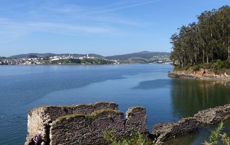
The Eo estuary has been a source of wealth for the area throughout time; the relationship of human beings with it has been, is and will be constant, and this is something that we can see throughout the route.
The estuary is in its full extent in our retina during a large part of the route; we see the life that moves, both human and animal. From this point of view, the Eo is still an important spot for the migratory birds that roost here every winter, such as geese, but not only for them.
Kestrels can be seen and heard in the area, in search of mice, voles or shrews that this rural environment favours.
If we pay attention, it will not be difficult to spot a roe deer or a small hedgehog at some point. Eucalyptus, oak trees and pastures make up the majority of the vegetation, and as for ethnography, in some arm of the estuary we can find an old tide mill.
Without a doubt, you must come and enjoy this Biosphere Reserve.
Beach of Arnao (Castropol) - A Veiga/Vegadeo 19,5
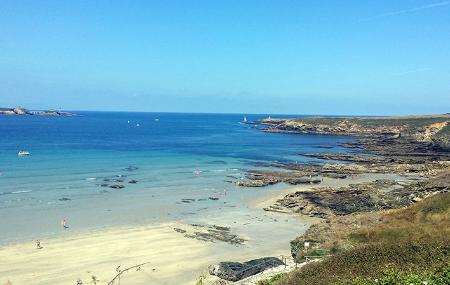
This coastal route begins at Arnao beach in Castropol, the westernmost beach in Asturias, which is reached by turning right before crossing the bridge of Los Santos, located over the river Eo, which joins the Principality of Asturias with Galicia.
From this beach we can enjoy the beautiful scenery of the Asturian and Galician coastline, with calm, crystal-clear waters and fine, white sand. It is located in the Ría del Eo Partial Nature Reserve and forms part of the Río Eo, Oscos and Terras de Burón Biosphere Reserve, so its beauty is unquestionable.
One kilometre into the walk, we cross the Cantabrian motorway, A-8, and the next kilometre we cross the AS-31 road, which passes through the village of Figueras.
After another 300 metres, we turn left and continue along the road, where we shall find the Das Acías tidal mill, at about kilometre 3, and the next kilometre we turn left towards Barres. On the way we can see the palace of Torres de Donlebún.
At kilometre 5, we reach Barres, where we can see the church of San Esteban. We leave the village and head towards the next one, Becharro, taking the paths that always go to the right.
Once we reach Becharro, kilometre 7, we continue our journey through woods and meadows, passing close by the villages of Salías, Cal and Cornayo until we reach Vilavedelle, at approximately kilometre 16.
Leaving the estuary on the right, we continue straight on and arrive at A Pruida, located three kilometres away from the previous point, kilometre 19. After 800 metres, we reach A Veiga/Vegadeo, the end of our route.