Foces del Raigosu mountain

- Les Mestres Central Asturias
- Distance: 12.67 kms
- Difficulty: Medio
- Cumulative difference in altitude: +637 m
- Cumulative difference in altitude: --637 m
- Maximum altitude: 1067.37 m
- Minimum altitude: 426.81 m
- IBP index: 65
- Modality: Senderistas
- Type of route: Ida y Vuelta
- Route type: Montaña
- Return by Train: No
The route offers geological diversity - limestone and siliceous rocks - and a rich variety of flora, with holly groves and masses of hazelnut trees standing out. The route enters canyons and waterfalls, discovering the remains of old mines and huts as you gain altitude. An opportunity to connect with nature and local history.
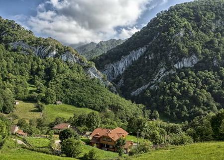
The route starts in Les Mestres, a small village located in the council of Laviana, specifically on the LV-5 road, just before reaching the picturesque village of La Fomermeya. Here, there is an information panel signposting the start of the route and a car park to leave vehicles.
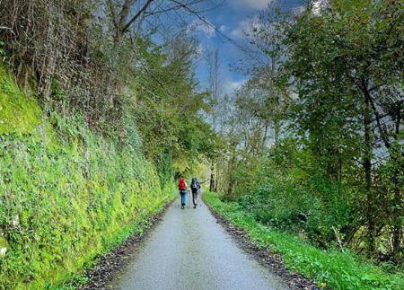
The first 600 metres of this path follow a track that follows the course of the river Raigosu, the same river that gives its name to this route. This initial section runs through a chestnut wood where the shade and the sound of the water create an atmosphere that characterises the whole route.
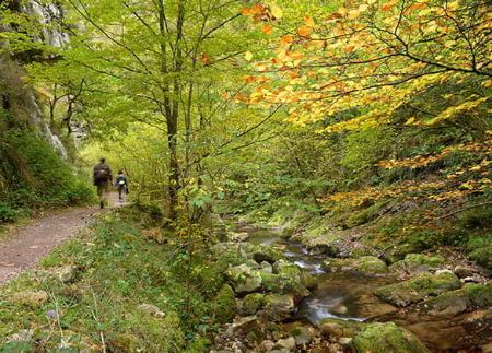
When you reach kilometre 1.5 from the starting point, there is a crossroads where you have to turn left, as the path on the right leads to the village of Los Tornos. On this same stretch you can see one of the points of interest: the enigmatic cave of Les Xanes, where you can make a brief stop before continuing. From this crossroads, the path becomes noticeably narrower and the vegetation undergoes a change, leaving behind the chestnut trees to give way to beech and birch trees.
Towards the middle of the route, at approximately kilometre 3, the Raigosu river joins the Gatu stream, marking a river meeting point. Here the path narrows considerably again, heading towards the ruins of an old mine. Immediately afterwards, the route enters its most challenging and narrowest point: the Foz de Cebellales, a stretch where the rocky walls close in, creating a sensation of total immersion in the mountain. The waters of the river Raigosu have gradually opened up this gap, cutting through both limestone and siliceous rocks, leaving a trail of canyons and waterfalls that make this path so unique.
After a further 1.5 kilometres, reaching kilometre 4.6, the path bids farewell to the Raigosu river and begins a gradual zigzag ascent up the slope of Los Collaos. This stretch offers the opportunity to gain height. Here there is a small fountain and a small viewpoint, ideal for a break to enjoy the views.
Finally, after walking approximately 6.5 kilometres, the route ends at the "majada de las Casas de Raigosu". Here you can contemplate the imposing limestone walls that form part of the Peña Mea mountains and see the famous "ojo de buey", a singular rock formation that crowns the landscape.
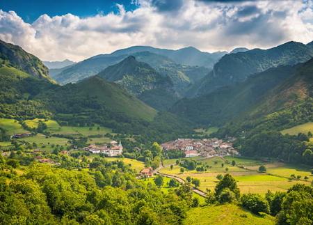
The whole route is a journey through the nature of Asturias, where the landscapes change at every turn and where you can also see traces of the region's mining past.
PR290
Basic tips before going into the mountains
- Avoid approaching livestock.
- If you find mastiffs protecting livestock, do not approach them, do not pet them and do not feed them. Do not allow them to follow you or stray from their herd. They are working.
- If you go with a dog, always keep it on a leash.
- Don't leave a trail. Collect all your waste, including organic waste. Nature is not a dumping ground.
- Act with prudence. Plan your route well, take everything you need and make sure it is adapted to your physical capacity.