Viewpoint of Següencu


- Cangues d'Onís/Cangas de Onís
- Distance: 23 kms
- Difficulty: Dura
- Total ascent: 700 m
- Maximum altitude: 750 m
- Minimum altitude: 85 m
- IBP index: 104
- One-day routes
- Type of bicycle: MTB
- Type of route: Circular
- Return by Train: No
The route starts at Plaza Camila Beceña, next to the Town Hall of Cangues d'Onís/Cangas de Onís, and heads east along Avenida Covadonga. After leaving the parish church and Casa Dago behind, take a detour to the left to cross the river Güeña over the Llerau bridge. A few metres further on, the route turns to the right to leave the town centre and skirt the Guardia Civil barracks.
After 300 metres, take a tunnel that crosses the Cangas by-pass and leads to a quiet, practically flat asphalted service road that leads to Celoriu. Before reaching the village, cross the CO-3 at the Cardes bridge, and the route continues parallel to the river Güeña. After crossing Celoriu, the same road joins the bridge that connects with the AS-114. At this point, turn right towards Cangues d'Onís/Cangas de Onís, and after about 150 metres take the signposted turn-off to the campsite.
The route crosses Sotu Cangues and joins the AS-262 towards Cuadonga/Covadonga, although it is soon abandoned to take the road up towards Torió. After crossing this small village, the dirt and gravel track begins, which will mark most of the ascent. The orientation is straightforward: just follow the main track, always going upwards except for a short flat or downhill section.
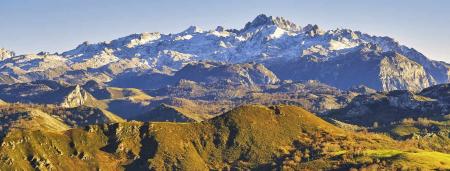
The climb is very attractive from a scenic point of view. The track, which is a land consolidation track, crosses livestock farms dotted with huts and wooded areas of ash, hazel and chestnut trees. Although the gradient is considerable and there are some steep slopes, the alternating breaks make the effort bearable. The road surface is usually in good condition, with compacted earth and some sections with loose stones due to the passage of agricultural machinery.
Once the hardest section has been overcome, at around kilometre 11.5, the route becomes smoother and allows the walker to advance through flatter areas. The houses of Següencu and the antennas on the summit are now very close. When you reach the first house in the village there is a wide crossroads: continue towards Següencu, descending a few metres until you join the local road. A small wooden signpost indicates the direction to the viewpoint.
The route ascends again along a comfortable track until, after about 300 metres, there is a concrete ramp that leads to the final slopes. The peak of Següencu is crowned by a forest watchtower and an antenna tower. A signposted path skirts these installations and leads to the viewpoint, with views of almost 360º and interpretative panels that allow you to identify the landscape.
After enjoying the surroundings, the descent to Cangues d'Onís/Cangas de Onís begins. It starts along the same route as the ascent, but when you reach the crossroads at the entrance to Següencu you continue towards the interior of the village. The track becomes asphalt and crosses the entire village. At the exit, after the last houses, take the first track on the left: a short concrete ramp that soon gives way to a flat stretch along the hillside.
The descent is straightforward: just follow the main branch that runs along the ridge towards Cangues d'Onís/Cangas de Onís. These are forest tracks with some concrete sections due to the steepness of the slope. At around kilometre 20.5 the track becomes asphalted again when it reaches the Llano del Cura recreational area. From here, just follow the road until you enter Cangues d'Onís/Cangas de Onís via the church of Santa María. The route descends along Calle Evaristo Sánchez, "La Carreterona", to the junction with Calle San Pelayo. Turn right to go around a block and return to the starting point in front of the Town Hall.