
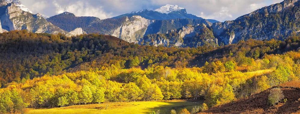
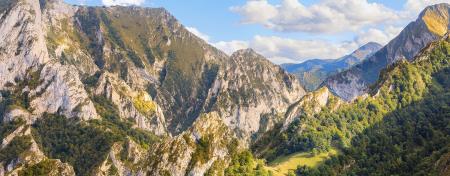
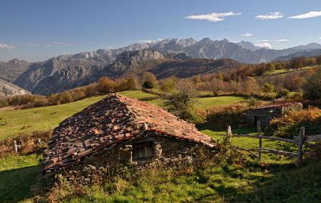
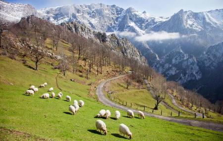
Ponga Natural Park
- Ponga Eastern Asturias
- Extension: 255 km 2
- Maximum elevation: 2.142 m. Peña Ten
Images


What to see
- Peloño Forest and Pierzu Peak Route.
- Taranes viewpoint and Les Bedules viewpoint.
- Interpretation Centre of the Ponga Natural Park.
- Villages such as Taranes, Sobrefoz, Viego, Casielles... which maintain the Asturian rural essence intact.
- Beyusque granaries.
- El Guirria and Aguinaldo festivals.
- Los Beyos Cheese PGI.
Info
In the Ponga Natural Park, dogs must be under the effective control of their owner, kept on a leash, except for herd guarding dogs, hunting dogs and guide dogs.
The Ponga Natural Park was declared a Biosphere Reserve by UNESCO in 2018. Among its most important mountain ranges is the sector of the Cantabrian Mountain Range that forms its southern boundary and forms the watershed between the basins of the Sella and Duero rivers, with peaks such as El Abedular (1,813 m.), Les Pandes (1,879 m.) and Peña Ten (2,142 m.), among others. The Cordal de Ponga forms its western boundary and includes notable peaks, such as Maciéndome (1,899 m.), Tiatordos (1,951 m.) and Campigüeños (1,838 m.), among others.

The most important rivers in the council are the Sella, which crosses the eastern part of the territory to continue its course through Amieva, and the Ponga, which runs through the council from south to north. The local tributaries of the Sella include the Roabín stream, the Mojizo river, the Porciles river and Santa Bustia. The most important tributaries of the Ponga are the rivers Taranes and Valle Moro. Most of these river valleys are narrow and their slopes are very steep, the most spectacular cases being the Desfiladero del Ponga and the Desfiladero de los Beyos.
The Ponga Park maintains a high environmental diversity, representative of the central-eastern mountains of Asturias, as well as a remarkable degree of conservation of its natural resources (geological, plant and animal).

From a geological point of view, the territory of the Ponga Natural Park is located in the so-called "Ponga Unit", whose most outstanding structural feature is the presence of a series of sinuous overthrusts, due to the existence of folds running across them. There is also an important set of fractures that cut both groups of structures, some of which have a notable lateral extension, as is the case with the Ventaniella Fault which, due to the Alpine Orogeny, has undergone vertical displacement with elevation of the northeastern block, thus giving rise to the mountainous alignment of the Cordal de Ponga.
ACTIVITIES NOT ALLOWED
- Causing a nuisance to the fauna or damaging the flora.
- Free camping, caravans or other mobile shelters (except bivouacking in ZUG, ZUA and ZAM).
- Water activities such as canyoning, white water rafting, rafting, etc. (with the exception of the Viboli and Carangas canyons, which will be authorised).
- Sporting activities with motor vehicles.
- Aerial sports activities such as gliding, parachuting, paragliding and similar activities.
Plant life
The Ponga Natural Park is in an excellent state of conservation, with 37% of the territory covered by oak, birch, ash, alder and, above all, beech forests. Within the park is the Peloño Partial Nature Reserve, one of the largest continuous beech forests in Asturias.
These forests are combined with meadows, pastures and scrubland, as well as chestnut plantations around San Xuan/San Juan de Beleño, Abiegos and Tarañes, and in the higher altitude areas and on the slopes of Tiatordos there are plant communities adapted to high mountain areas.
The park contains flora included in the Catalogue of Threatened Flora of the Principality of Asturias; these species include yew, holly, Asturian daffodil and gentian.
Wildlife
The Ponga Natural Park brings together the characteristic fauna of the central-eastern Asturian mountains. Among the mammals, in addition to the typical mountain species, brown bears can be seen sporadically. The otter and the desman (a species of mole with a long, flexible snout) are present in most of the rivers, which reflects the good quality of their waters. The European hare is abundant in the meadows, and Ponga is one of its last refuges. There are also deer, roe deer, chamois and wild boar.
The park is home to a rich and diverse bird life. The Cantabrian capercaillie, the middle spotted woodpecker and the black woodpecker, listed as species sensitive to the alteration of their habitat in the Regional Catalogue, stand out. Birds of prey such as golden eagles, griffon vultures, Egyptian vultures and goshawks are also present. In the higher areas, species linked to the high mountains can be observed, such as the alpine sparrow and the grey partridge.
Map
Interpretation Centre of the Natural Park of Ponga
33557 San Xuan/San Juan de Beleño. Ponga
Telephone 985 843 113