
- Langreo, Laviana, Sobrescorbio and Caso Asturias Centre
- Distance: 54 kms
- Difficulty: Short
- Cars: 5 days
- Start point: Sama
- Layout of the route: Download kml
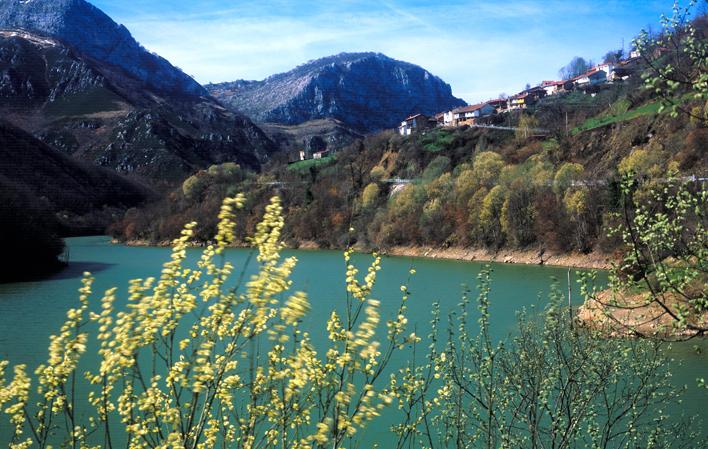
To speak of the Nalón is to speak of the river and also of the coal basin, as the remains of the industrial archaeological heritage are to be found in its valley.


Info
To say Nalón is to speak of the river and also of the coal basin. So, in its valley, the remains of the industrial archaeological heritage are the first to strike the traveller's eye. But those who scratch beneath the surface will find unique examples of architecture, high quality gastronomy and a natural park that has been declared a Biosphere Reserve by UNESCO.
Route
Sama - La Nueva - Ciañu 10,9
Day 1: The journey begins in the surroundings of the largest urban centres of the Nalón Basin, Sama and La Felguera. One of the two best examples of its industrial past is the MUSI, the Iron and Steel Museum, located inside a forty-five metre cooling tower in the Valnalón industrial estate. The other example of its industrial past is the Samuño Ecomuseum, in La Nueva on the LA-7 from Ciañu, an exhibition complex in the old San Luis Well, which includes a two-kilometre journey in a mining train.
The Eduardo Úrculo Municipal Art Gallery, opened in a former slaughterhouse dating from 1919, is another reference centre. Ciañu also has several gems, such as the Torre de la Quintana and Casa de los Solís complex, built in the 14th century, and the Casa de la Buelga, a Baroque building currently used by the University of Oviedo.
Ciañu - La Pola Llaviana/Pola de Laviana 16
Day 2: The route heads south along the AS-17, known as the Nalón Corridor. In L'Entregu / El Entrego, you will find the MUMI, the Mining Museum, which has a reproduction of a coal shaft mouth and the 'cage' in which the miners descend into the bowels of the earth. Within the town centre, you can stroll through the mining districts of La Vega, San Juan, Santa Bárbara and El Coto, which are examples of the region's working-class architecture. The typical dish of L'Entregu / El Entrego is stuffed onions, which even have a popular festival in autumn. Further south, in Sotrondio, from the neighbourhood of El Pontón, the Santa Bárbara Valley path begins, which follows the old railway line from La Cerezal to the Hullera washhouse.
La Pola Llaviana/Pola de Laviana - Rusecu/Rioseco 13,5
Day 3: La Pola Llaviana/Pola de Laviana takes up the third day. Next to the cemetery in La Pola, the capital of the council, is the Sanctuary of the Virgen del Otero, a 15th century building with a unique Baroque altarpiece. One of the typical dishes of this town is bartolos, sweets made from ground almonds and puff pastry. A kilometre and a half to the south are Entrialgo and the Casa Natal de Armando Palacio Valdés (Armando Palacio Valdés Birthplace), a rural mansion dating from the 17th century. In this interpretation centre you can learn about the writer's work. From the outside of the centre there is a route that connects with Canzana and follows the settings of La Aldea Perdida (The Lost Village), perhaps his most famous novel. Next is the Puente de Arco (Arch Bridge), a Romanesque footbridge with two semicircular arches. Between this bridge and that of La Chalana, a no-kill trout fishing reserve has been established.
Rusecu/Rioseco - Soto - Rusecu/Rioseco 6,77
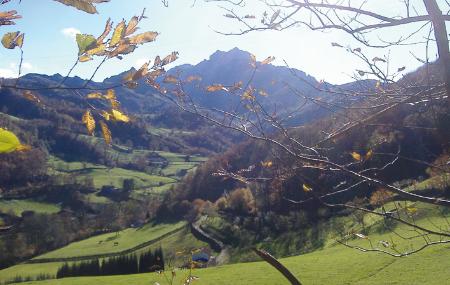
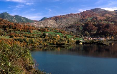
Day 4: The traveller arrives at the council of Sobrescobio and, therefore, at the gateway to the Redes Natural Park, declared a Biosphere Reserve by UNESCO. Its capital, Rusecu/Rioseco, is nestled between two reservoirs, Tanes and Rioseco, which run parallel to the AS-17. The village is home to the Water Reception and Interpretation Centre (check availability of equipment beforehand), a museum that goes a long way to explaining the beauty of the surroundings. Just three kilometres away on the SC-2, you will find Soto, which is the starting point of the Ruta del Alba, a popular mountain trail, measuring fourteen kilometres (outward and return). The first kilometres of this route are accessible. On the way back to Rusecu / Rioseco you can stop off at the Villamoréi recreation area. One of the most typical dishes in this area is lamb cooked on the spit.
Rusecu/Rioseco - Tarna - Rusecu/Rioseco 60,7
Day 5: The source of the Nalón, the river that accompanies us throughout the journey, is near El Campu. Its source is the Fuente La Nalona, in El Puertu. In this area we can complete the Tabayón de Mongayo route, which starts in the village of Tarna and is 9 kilometres long. On the way back to El Campu, the Redes Reception and Interpretation Centre opens its doors in the capital of Caso. This facility has a permanent exhibition on the reserve, but also offers practical information on the routes that can be followed. To end the day, you can organise a pleasant walk with the children around the Deboyu Cave, a karst cavity carved out of the rock by the river Nalón and located next to El Campu. As for gastronomy, Casín cheese has become a reference point and different producers now offer guided tours of their cheese dairies.