- Address Navia, Tapia de Casariego, Boal and Coaña Western Asturias
- Distance Distance: 69 kms
- Difficulty Difficulty: Short
- Cars Cars: 5 days
- Start point Start point: Tapia de Casariego
- Route type Route type: car
- Layout of the route Layout of the route: Download kml
With an area of 777 square kilometres and 9 councils, the Navia Historical Park paints on the map an imperfect triangle in the interior of Asturias.
Info
With a surface area of seven hundred and seventy-seven square kilometres and nine councils, the Navia Historical Park paints an imperfect triangle on the map in the interior of Asturias, bordering Galicia and the Cantabrian Sea. This castreña region, mixes two types of territories, the sea and the mountains.
Route
Tapia - Navia 28
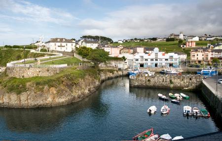
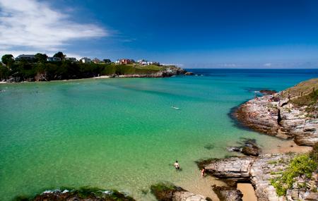
Day 1: The Navia Historical Park has three entrance gates that bring the traveller closer to this region. This journey begins at the gateway to Tapia, an interpretation centre located in the House of Culture, which revolves around the palatial houses. In this town, you can visit its fishing port, stroll to the lighthouse and the beaches of El Anguileiro. From Tapia there is a section of the coastal path to El Porto/Viavélez, which is seventeen kilometres long. It is also possible to cover only part of the route, up to Monte Mirayos, to discover the Campo Longo viewpoint.
Accessible by car is the La Atalaya viewpoint, in Valdepares (El Franco), which can be reached from the N-634 and via a road at the end of the village. Another option is Cape San Agustín, in Ortigueira, which shelters a 17th-century chapel and a monument to the men of the sea, as well as a privileged view of the port and the Navia estuary. On the way back, we highly recommend a stop at the Mohías castro, an example of a castreño settlement in western Asturias.
Navia - Puerto de Vega - Cuaña 25,2
Day 2: The day begins in the town of Navia, to lose yourself among its town hall, the church of Nuestra Señora de la Barca, the medieval wall and the Casa de Coaña. The local road NV-2 connects Navia with Frexulfe beach, a natural monument, which has a rest area under a wooded area. Following the NV-2 we reach Puerto de Vega, a village known for the beauty of its quay, its ancestral homes and which manages the second gateway to the Historical Park. It is necessary to retrace our steps to discover the first military remains. Seven kilometres from Navia, this time on the AS-12 in the direction of Bual, is the Castro de Coaña, a site which preserves eighty huts protected by a thick wall and which organises guided tours.
Coaña - Villayón - Boal 67,8
Day 3: The journey turns inland to Asturias via the AS-25. The route continues along this road until, once past the village of Arbón, it turns towards Oneta on the AS-36. There, two kilometres from the village, there are three waterfalls of spectacular beauty that take their name from the town. The largest has a free fall of 20 metres. Back on the AS-25 we reach Villayón, and in half an hour on the AS-35, we reach Valdedo, where the Interpretation Centre of the Protected Mountain Landscapes is located (check availability of the equipment beforehand). We continue on to Bual, along the AS-35. On this stretch, before the village of Merón, is the Puente de Castrillón recreational area, an opportunity to enjoy the Arbón reservoir.
Boal - Pesoz 71,7
Day 4: Boal is a land of honey. Just two kilometres from the village, on the AS-12, is the Casa de la Apicultura (check availability of equipment beforehand), and four kilometres further on is the Castro Pendia. On the way back to Bual, it is also the starting point for the ascent to the Alto de Penouta, on the AS-22. There are two viewpoints at this peak, via two asphalted paths. The one on the right leads to the Penouta Costa viewpoint, with a clear view of the coastal strip. The one on the left ends at Penouta Interior, with a view of the mountain.
It is necessary to return to Bual to take the AS-12 which leads south. Twenty-five kilometres away (about forty minutes' journey), you will find San Esteban de los Buitres in Illano, a village with a sonorous name and a heritage site declared an Asset of Cultural Interest. On the way, a little more than a kilometre after Doiras, we can make a stop to take a close look at the Doiras reservoir and its dam. Continuing along the road for about eight kilometres we can make a stop at the Folgueiróu recreational area. The penultimate stop, already in Pesoz, is in the village of Argul, which preserves a unique architecture. It is necessary to take a detour after crossing Pelorde. The day ends in Pezós / Pesoz.
Pesoz - Grandas de Salime 24,9
Day 5: Grandas de Salime is the southernmost point of the region and offers the last gateway to the Park. At this strategic point, seven kilometres from the capital of the council, is the Chao de Samartín Museum, next to the castro that gives it its name. This site is one of the most important in the region. The Samartín hill fort has remains dating from 800 BC. On returning to Grandas de Salime, a visit to the Ethnographic Museum is a must.
In the area, the Grandas de Salime reservoir stands out, a spectacular 20th century work, which includes decorative elements by Joaquín Vaquero Palacios and a unique viewpoint, called La Boca de la Ballena, by his son Joaquín Vaquero Turcios.
Map
Itinerary
Tapia - Valdepares - Ortigueira - Navia - Puerto de Vega - Mohías - Oneta - Valdedo - Bual - Sanesteba - Pezós/Pesoz - Grandas de Salime


