Cliffs of Hell

- Toriellu Eastern Asturias
- Distance: 11.06 kms
- Difficulty: Easy
- Cumulative difference in altitude: +181 m
- Cumulative difference in altitude: -181 m
- Maximum altitude: 70 m
- Minimum altitude: 17 m
- IBP index: 31
- Modality: Families
- Type of route: Circular
- Route type: Coast
- Return by Train: No
This itinerary includes the cliffs of Castro Arenas and Tomasón, Pozo Tuerba and the islets of Palo Verde and Palo Pequeño.
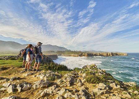
The Acantilados del Infierno route begins at the Guadamía recreational area, an accessible point that marks the start of this spectacular coastal walk. Before starting the route, it is worth taking a look at the Bufones de Pría, located on the other side of Guadamía beach. This natural phenomenon occurs when the sea hits the base of the cliffs with force and the water is expelled with great pressure through cracks in the rock, creating an impressive spectacle. However, it does not occur at all times, as it depends on the swell conditions, being more frequent in the winter months, when strong swells generate the effect with greater intensity.
The route follows the coastline, allowing you to contemplate the immensity of the Bay of Biscay and the fierceness of its waters as they crash against the cliffs of Castro Arenas and Tomasón. These majestic rock formations offer a landscape of great drama, where the sound of the waves and the wind accompany the walker at all times. A detour of barely 80 metres leads to the Yara viewpoint, from where you can enjoy privileged views.
About 500 metres further on, we find the Tuerba well, an impressive stone arch sculpted by marine erosion, which is one of the most impressive points along the route.
The path continues with panoramic views of the cliffs, crossing strategic viewpoints that offer safety and a spectacular perspective of the surroundings. The Ollianco viewpoint and the Cabecina viewpoint stand out, from where you can see the islets of Palo Pequeño and Palo Verde, small rock formations that emerge from the sea.
The route takes us to the Infierno recreational area, where we can take a break before returning. From here, there are three options for returning to the starting point:
1️⃣ Retrace our steps, allowing us to once again enjoy this spectacular stretch of coastline from a new perspective, with the light and landscape changing according to the time of day.
2️⃣ Continue along the signposted path to Ribadesella/Ribeseya, extending the route to explore this part of the Asturian coast in more depth.
3️⃣ Opt for a circular return along the Camino de Santiago, the alternative we have chosen for this route. To do so, we follow the path for 400 metres and turn left, linking up with a more inland section, where the atmosphere changes to a quieter landscape.
Following the Way of St. James, we reach the hermitage of San Martín, where we cross the tracks over an overpass and continue along a comfortable path that leads us to the beach of Guadamía, practically back to the starting point.
Along the way, the route offers a unique combination of geological formations, spectacular cliffs, native flora and fauna, making it a complete experience for nature and hiking lovers. The Acantilados del Infierno route is not only a moderate physical challenge, but also invites a deep connection with the Asturian coastal landscape, allowing you to enjoy some of the most impressive corners of the coast of Ribadesella.
- It runs partially through the ZEC and ZEPA Ría de Ribadesella - Ría de Tinamayor of the Natura 2000 Network.
- The route partially coincides with the Pilgrims' Route to Santiago de Compostela.
- Area of cliffs with danger of falling.
- Local path signposted by Ribadesella Town Council (one way).
Basic tips before going into the mountains
- If you go with a dog, always keep it on a leash.
- Avoid approaching livestock.
- If you find mastiffs protecting livestock, do not approach them, do not pet them and do not feed them. Do not allow them to follow you or stray from their herd. They are working.
- Don't leave a trail. Collect all your waste, including organic waste. Nature is not a dumping ground.
- Act with prudence. Plan your route well, take everything you need and make sure it is adapted to your physical capacity.