Sierra de Carondio Archaeological Route
- Address Allande Western Asturias
- Distance Distance: 7,7 kms
- Difficulty Difficulty: Short
- Altitude Altitude: 1.170 m.
- Unevenness Unevenness: 139 m.
- On foot On foot: 3 h. 30 min. Round trip
- Start point Start point: Alto de Bustantigo
- Route type Route type: Hiking
- Tour type Tour type: Round trip
- Layout of the route Layout of the route: Download kml, Download gpx
Info
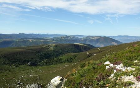
A comfortable forest track takes us along the crest of the Carondio mountain range, where the environmental impact study for the wind farm that we find here today uncovered a rich archaeological heritage, now converted into this route that reveals this magnificent landscape of western Asturias from this vantage point, while taking us back to the beginnings of our civilisation.
The vegetation is dominated by heathery heathland, dotted with pastures and some patches of pine forest in the upper part. The autochthonous forests are submerged in the watercourses and deep valleys trodden by the water over these lands. And along the way, the remains of tomb necropolises, cazoletas (small cavities dug into the rock) and ancient Roman camps.
And in the distance, a landscape of mountains separated by deep valleys, on a route that runs partly parallel to the Pilgrims' Route to Santiago de Compostela, which we can see passing through the southernmost mountain, at the height of the Palo pass, descending towards Montefurado. History, landscape and nature in the same place.
Route
Alto de Bustantigo - Carondio Mountains 15,4
This landscape, which enjoys protection, preserves innumerable vestiges of ancient settlers, specifically from Neolithic prehistory, where there are numerous burial mounds. More than two dozen burial mounds have been catalogued on this route, including the dolmen located at the foot of Pico Carondio, popularly known as A Llastra d'Afiladoira. We reach the Alto de Bustantigo or Collado de Cruces (1,028 metres) via the ALL-5 road from the Alto de la Marta (ALL-4), both coming from kilometre 38.5 of the AS-14 road.
After the first 450 metres of the route, we come to the car park, where there is a signpost indicating the village of Zaporrel; we take the dirt track, an old cow track called La Carreiriega de los Gallegos, which climbs up to the left.
After 1.5 kilometres, we come to a crossroads, where we turn slightly to the left and continue straight on along the track. At this point we can see Pico Agudo (1,143 metres), which has a metal cross on its summit. It is one of the most rugged mountains in western Asturias.
At kilometre 4, the path forks, and we opt for the path to the right. Approximately one kilometre further on, we find ourselves in the tomb area known as Veiga de Abades, where the "dolmen stone" of Allande comes from, which is kept in the Oviedo Archaeological Museum. It is one of the most prized pieces in the museum, and measures 1.95 metres long by 0.35 metres wide and 0.12 metres thick.
Having reached kilometre 7, we are almost at the end of our route and can enjoy the scenery and the beautiful views. To return to the starting point we must go along the same track but in the opposite direction.
Map
Detail
This landscape, which enjoys protection, preserves innumerable vestiges of ancient settlers, specifically from Neolithic prehistory, where there are numerous burial mounds. More than two dozen burial mounds have been catalogued on this route, including the dolmen located at the foot of Pico Carondio, popularly known as A Llastra d'Afiladoira. We reach the Alto de Bustantigo or Collado de Cruces (1,028 metres) via the ALL-5 road from the Alto de la Marta (ALL-4), both coming from kilometre 38.5 of the AS-14 road.
After the first 450 metres of the route, we come to the car park, where there is a signpost indicating the village of Zaporrel; we take the dirt track, an old cow track called La Carreiriega de los Gallegos, which climbs up to the left.
After 1.5 kilometres, we come to a crossroads, where we turn slightly to the left and continue straight on along the track. At this point we can see Pico Agudo (1,143 metres), which has a metal cross on its summit. It is one of the most rugged mountains in western Asturias.
At kilometre 4, the path forks, and we opt for the path to the right. Approximately one kilometre further on, we find ourselves in the tomb area known as Veiga de Abades, where the "dolmen stone" of Allande comes from, which is kept in the Oviedo Archaeological Museum. It is one of the most prized pieces in the museum, and measures 1.95 metres long by 0.35 metres wide and 0.12 metres thick.
Having reached kilometre 7, we are almost at the end of our route and can enjoy the scenery and the beautiful views. To return to the starting point we must go along the same track but in the opposite direction.


