- Bed places Bed places: 96
- Address Cabrales Eastern Asturias
- Address Address: ■ 33554 - Vega de Urriellu. Macizo Central (Urrieles)
- Phone Phone: 984 090 981 / 638 278 041 / 650 780 381
- Site Site: https://www.reservarefugios.com/
- Closed Closed: 15/12 a 15/03
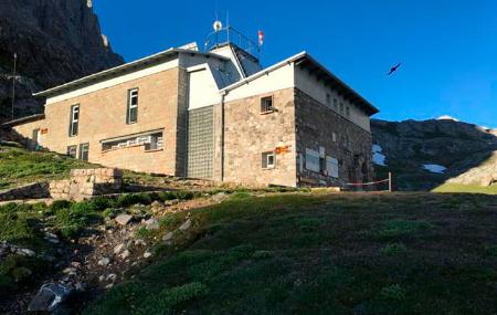
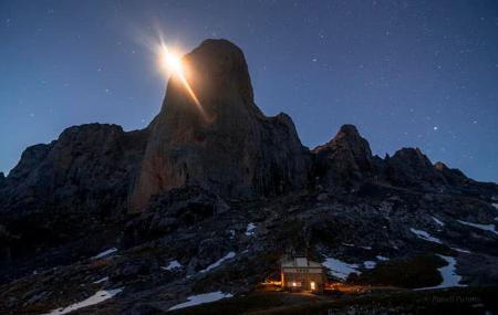
The current building was constructed during the summers and autumns of 1989-1990. The transport of materials was carried out by an Army "Chinouk" helicopter and other rented helicopters. It was inaugurated on 14th October 1990.
Access from Collado Pandébano via La Terenosa and Collau Valleju follows a footpath that was opened in 1986, until then access from Cabrales was via Cambureru.
For the construction of the first refuge in the Vega de Urriellu, stone from the Vega itself was used. It had two floors: on the upper floor, which was accessed by an iron staircase and almost vertical, there was a continuous bunk bed with a capacity for nine people, which could be increased to fifteen, and on the lower floor there were wooden tables and chairs, shelves for cooking and folding bunks.
The work began in the summer of 1953, the cement and beams were carried on shoulders from Puente Poncebos, through Bulnes, Cambureru and Jou Lluengu, crossing a difference in height of 1700 m. In forty-seven days it was possible to close the waters and finish the main works at the end of September.
It was inaugurated on 5 August 1954, coinciding with the 50th anniversary of the first ascent of Picu Urriellu. In the following decade it became too small to receive the large number of climbers who sought its services and it was decided to enlarge it. The current refuge still has the complete façade of the previous one.
How to get there
- From Sotres
Difference in altitude: 1073 m
Time required: 3 hours and a half to 4:00 h.
From Arenas de Cabrales follow the road to Poncebos, and continue towards Sotres. When the road makes a sharp bend to begin the final ascent to the village of Sotres, continue without changing direction along a track that leads to Áliva and Pandébano (signs indicating the Picos de Europa National Park guide you).
After seven hundred metres we turn off to the right, and descend through the Invernales del Texu to cross the Duje River over the Moyeyeres Bridge. The track is not suitable for cars, but, for the moment, they allow us to go up. It steepens up to Collau Cuaceya, continues flat, and later crosses the Arroyo Canero. From the Canero stream and heading west, we go halfway up the slope on a marked path to Collado Pandébano (1212 m). We head south and then SW towards Mayada de la Trenosa (1315 m), with a fountain and refuge.
From here, following a path above La Varera mountain, we flank in a south-westerly direction until we reach Collau Valleju (1540 m), from where we can see the north face of the Picu, with the permission of the mist. The last 400 m of ascent to the refuge crosses the Canal del Valleju, Las Traviesas and the eastern edge of Jou Lluengu, with a steep slope and frequent zigzags. Near Vega de Urriellu (1960m) we will see a detour on our left, which we should avoid, as this is the lower entrance to the Canal de la Celada.
- From Bulnes via Puente Poncebos
Altitude: 1735 m
Aproximate duration: 5 to 7 h.
We walk along the road that runs parallel to the left bank of the River Cares, leaving the Torbanes Bridge on that side, which would take us to the lower station of the Bulnes funicular railway and to Sotres, and on the opposite side two hotels and the turn-off to Camarmeña.
After passing a short tunnel we descend to the left to cross the Cares by the Jaya Bridge, follow the path that runs along the Teju canal, and leaves us directly in the village of Bulnes, leaving the exit of the funicular on the left, we reach the village of Bulnes, passing by the Chiflón house, we take the path that leads to Cambureru, with the river on our left, we ascend -SE- towards the Mestas waterfall, which has an inclined and dangerous section if it is wet (protected with cables to hold on to); the
The path climbs rapidly and then enters the Balcosín channel, which is straight, easy to walk and slopes down towards the south.
At the end of this channel, which becomes sharply narrower and steeper, we have reached the gorge, with a spring.
Turning towards the west we reach the Jou Baju and begin the ascent along the Cambureru channel, the hardest stretch of the whole approach walk; a very steep slope, a path that gets lost in the rocky area, a half-buried block that almost closes the channel. Further up we find the fountain and the esplanade where there are remains of huts (1385 m).
We turn left and further up to the right. As we ascend the rocky slope on the right, the horizon widens and we come out onto the upper part of Jou Lluengu, passing through a small, easy climb (be careful if there is snow), we reach the Urriellu valley (1960). The route is marked as PR by the park (white and yellow paint).
Email of the refuge: refugiodeurriellu@hotmail.com
- Heating
- Kitchen-bar
- Dining room
- Toilets
- Mattresses
- Duvets
- Pillows
- Bar
- Breakfast, lunch and dinner service
- Sandwiches - tapas - Snacks - Pic-Nic
- Hot and cold drinks
- Radio-Helpline
- Locker area
- Games and magazines
- Backpacker
- Outdoor fountain
- Closed Closed: 15/12 a 15/03
Reservations only on this website: www.reservarefugios.com
When the ranger is not present, the refuge has 12 places with mattresses and water nearby.
How does a mountain refuge work?