

Between capes. From Vidio to Busto
- Cudillero and Valdés Western Asturias
- Distance: 28 kms
- Difficulty: Short
- Cars: 2 days
- Start point: Cudillero
- Layout of the route: Download kml
Valdés and Cudillero, land of sailors and cowboys, the most authentic mixture of sea and mountain that can be found in the heart of Asturias.


Info
They are Cudillero and Valdés, land of sailors and cowboys, the most authentic mixture of sea and mountain that can be found in the heart of Asturias: brañas and ports that nourished their inhabitants and gave them an identity of their own, difficult to understand if you don't know their houses hanging over impossible cliffs.
Route
Cudillero - Cape Vidio 20,5
The route begins in Cudillero, one of the most picturesque ports, with an amphitheatre of houses. The best thing to do is to leave the car at the port and wander through the steep streets at the pace that your breath allows. The best advice is to get lost in the narrow streets and viewpoints, albeit with a certain order, and the walker can follow the blue-painted railing that zigzags between the fishermen's houses. The didactic classroom Los Pixuetos y el Mar, inside the old fish market, or the mural El Pescador by the painter Casaus, are the perfect complement.
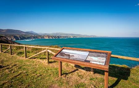
The afternoon is reserved for the Quinta Selgas palace. Located in El Pito, two kilometres from Cudillero, the complex is made up of gardens that protect the buildings. Inside is an exclusive art collection that the Selgas Fagalde family donated to the Asturians. It is necessary to make an appointment in advance. From La Quinta, via the Autovía del Cantábrico (A-8), the journey continues west. In Soto de Luiña, you can visit the complex formed by the church of Santa María and the Casa Rectoral, declared Sites of Cultural Interest. The last stop of the day, in Oviñana, is Cape Vidio, with its 80-metre high cliffs and lighthouse.
Cudillero - Luarca/Ḷḷuarca 58
The second day will try to concentrate the essence of Valdés, whose capital is Luarca/Ḷḷuarca. On this occasion, the excursion will run from west to east. The first visit of the day will be to the Barayo Nature Reserve, which is accessed from the westernmost tip of Outur. The landscape combines the beach, a dune system and slightly saline marshes. It is necessary to leave the car in a car park and explore the area on foot.
From nature to asphalt in Ḷḷuarca, where we find three different areas, the oldest area, the seafaring area, with its three typical neighbourhoods (Cambaral, Carril and Pescadería), forming an amphitheatre around the port. The bourgeois area, where the town hall, the park, the Círculo Liceo (casino) and some other modernist-style buildings are located. And the Indian area, Viḷḷar, in the upper part of the rasa with all its late 19th-century mansions. The final stretch of the day will be concentrated at Cabo Busto, a perfect plain on which the lighthouse stands, accessible from exit 462 of the Autovía del Cantábrico (Cantabrian motorway). It can be reached by car or on foot, along a path from the village of Bustu (7 kilometres), which is circular and leads from the chestnut trees and pastures to the cliffs.