
On the shores of Cape Peñes
- Carreño and Gozón Asturias Centre
- Distance: 28,7 kms
- Difficulty: Short
- Cars: 2 days
- Start point: Cape Peñas
- Layout of the route: Download kml
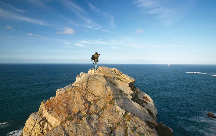
Cape Peñes, the most northerly point of Asturias, is the land battered by the north winds, built on impossible cliffs.


Info
Like a spearhead in the sea, Cape Peñes is the northernmost point of Asturias. It is the land battered by the north winds, built on impossible cliffs. From the sea, it appears as a giant pierced by underwater caves, with vertiginous cliffs and plateaus of green meadows with unexpected ends, unique lighthouses and fishing villages. Such a land imprints character.
Route
Candás - Lluanco/ Luanco 5,6
To the east, Carreño, with its capital: Candás. The traveller can park the car, because it is a town to be enjoyed on foot. A good starting point to understand its idiosyncrasy is the port. From this inlet you can climb up to the San Antonio hermitage and the lighthouse, with its spectacular views. Halfway up is the Antón Museum, located in the Plaza de El Cueto. Inside and in the gardens you can see the works of the local sculptor Antonio Rodríguez García. Walking inland, you come across the park of Les Conseveres, a green lung of more than 7,000 square metres. In the old cistern of the B. Alfageme canning and cider factory, there is an exhibition on the history of the city. Alfageme, an exhibition on the canning industry recalls what was one of the economic engines of the town.
The afternoon invites you to leave the urban terrain. Those who combine physical fitness with literary interest can opt for the Clarinian Route, which follows in the footsteps of the author of La Regenta, Leopoldo Alas Clarín, in Carreño. This visit, of medium difficulty, is 14 kilometres long, but is divided into three parts (they are not connected) that show landscapes described in three of Clarín's works: Doña Berta, Viaje Redondo and Boroña. It is a unique literary-tourist experience.
Lluanco/ Luanco - Beach of Xagó 23,1
Lluanco/Luanco, capital of the council of Gozón, is the starting point for the second day. Armed with comfortable shoes, tourists can begin their visit at the Maritime Museum, in Calle Gijón, and then head out to La Ribera beach, the Clock Tower, the old port and the church of Santa María, which is resistant to the sea winds. The excursion continues along the beach promenade, where a flight of steps starts. This is the starting point of another coastal path. For the less adventurous, there is a small park hanging over the sea at the start. Those who want more adventure can continue on to Bañugues, four kilometres away.
At the end of the trip, in the afternoon, Cape Peñas and its protected landscape, with cliffs, paths and viewpoints, will remain fixed in the traveller's mind. From Lluanco/Luanco, the most direct road is the GO-1. The lighthouse, on the ground floor of which there is an interpretation centre, will also serve as a guide for the car. From Peñes, via the AS-238, the route continues along the western coast of Gozón, with unforgettable sunsets on the plateaus overhanging the sea at Verdicio or in the dunes of Xagó.