

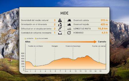
Stage 2: Alles - Carreña
- Peñamellera Alta and Cabrales Eastern Asturias
- Distance: 15,75 kms
- Difficulty: Half
- Code: GR109 Asturias Interior - Stage 2
- Altitude: 529,06 m.
- Unevenness: 646 m.
-
On foot:
4 h. 30 min.
One way
- Start point: All
- Tour type: Crossing
- Layout of the route: Download kml


Info
From Alles, the route runs from east to west along the southern face of the Sierra del Cuera, a mountain massif declared a Protected Landscape that is located barely four kilometres from the coast, between the sea and the highest peaks, delimiting two distinct geographical areas on both sides, La Marina llanisca and El Trascuera.
Route
Alles - Carreña 15,75
The second stage of the GR starts in Alles, the capital of Peñamellera Alta, located at the foot of the Sierra del Cuera, and continues westwards along the southern face of the mountain massif, before descending in its last stretch to Carreña, in the council of Cabrales.
The route begins next to the local clinic in Alles, where the information panel at the start of the stage is located. Several directional signs mark the route to follow.
On the outskirts of Alles are the remains of the church of San Pedro de Plecín, a beautiful late Romanesque temple dating from the 11th-13th centuries. It was built over another pre-Romanesque church and archaeological remains of a large medieval necropolis have also been found underneath it. The church of San Pedro de Plecín remained standing until the 18th century under the patronage of the Mier family and was converted into a cemetery when the neighbouring church of San Pedro was inaugurated.
In the first part, the stage makes a steep descent towards the valley of the river Janu, a tributary of the Cares, along a path through Euro-Siberian holm oak groves(Quercus ilex and Quercus rotundifolia), protected by regional legislation and classified as being of special interest, and also featuring typical species in the area, such as oaks(Quercus robur), hazelnut trees(Corylus avellana) and chestnut trees(Castanea sativa). In this section, we must pay attention to the directional signs, especially after crossing the river Sedo.
Afterwards, the path comes out onto an asphalted road and continues gently uphill along it, parallel to the river Janu and between slopes of heather(Erica sp.) and gorse(Ulex europaeus). After crossing the bridge over the Rumor river, the route turns off to the left and continues along a gravel track. The route continues and a few metres further on, you will cross the river Janu, where you will have to take extreme precautions, as there is no crossing point. We must also pay special attention to the directional signs. A little later, we will cross the river again, this time over a stone bridge. The route climbs moderately steeply up to Rozagás, from where we can see the limestone pastures and the Sierra del Cuera, at the back of the path.
From Rozagás, the route continues ascending along the AS-345 road to a sheepfold dividing the municipalities of Peñamellera Alta and Cabrales. At this point, the road descends a slight slope to Arangas, crossing this rural village. A short distance from there, and once past the watercourse, the route continues along a track, which climbs up to the right of the road between pastures and copses of chestnut and oak trees.
In this part of the stage, the path ascends quite steeply, in some sections on concrete, to Pandellamas. Once we reach the pass, we must pay attention to the directional signs, as the route turns off to the left and, shortly before reaching some huts, it turns left again, descending steeply beside a stone wall, towards the junction of two streams. Once you have crossed the streams, the path continues steeply uphill and goes around a pasture bordered by a stone wall and chestnut trees. In this part of the stage, you will enjoy fantastic panoramic views of the Sierra Pañalba and, behind it, of the Picos de Europa, with the Picu Urriellu perfectly visible.
The ascent ends at the Collau de Pandejana, where a gravel track begins, with concrete in some sections, and along which we will continue the rest of the descent until we reach the end of the stage in Carreña.