
Aristébano, in search of El Dorado
- Valdés and Tineo Western Asturias
- Distance: 62 kms
- Difficulty: Short
- Mountain bike: 2 days
- Start point: Almuña
- Tour type: Linear
- Layout of the route: Download kml

Route
Almuña (Valdés) - Navelgas (Tineo) 30
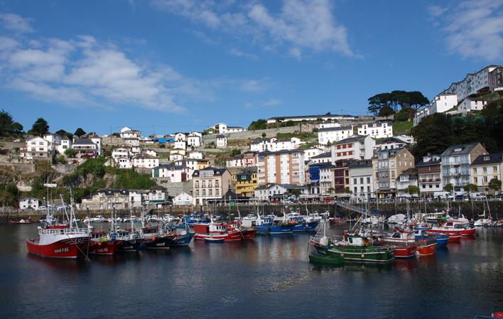
This route starts in the village of Almuña and, parallel to the river Negro, heads towards the village of Luarca/Ḷḷuarca, capital of the council of Valdés. Alternatively, you can start the route in Luarca, a town with a train station (unlike Almuña).
Luarca/Ḷḷuarca has several interesting places to visit, such as the lighthouse, the indianos' houses, the Mesa de Mareantes or the cemetery which houses the tomb of Doctor Severo Ochoa, winner of the Nobel Prize for Physiology and Medicine. The legend of Cambaral hangs over the town, where Cambaral himself (a Moorish pirate), the daughter of the lord of Luarca and the bridge of El Beso converge. Among its festivities is San Timoteo, celebrated on 22 August.
Once you have visited the capital of Valdés, take the AS-219 road to Navelgas, the end of this route. As soon as you leave Luarca, there is a steady but pleasant climb to the top of Aristébano. Along the way, the route passes through the hamlet of La Figal, from where there is a picturesque view of the town of Luarca/Ḷḷuarca with the Cantabrian Sea in the background.
The route then passes through the slope of Estoupo peak, and further on through the village of Caborno, to shortly after reach the Aristébano pass and the Aristébano hut, the summer residence of the community of the Vaqueiros de Alzada and an obligatory stop on this route.
The Vaqueiros de alzada or simply vaqueiros are a cultural or social group, and one of their defining characteristics is their transhumant way of life. At certain times the vaqueiros "raise" their dwellings and belongings and go with their livestock to the brañas above in summer or to the braña below in winter (braña is the name given to the area of mountain pastures for livestock).
With the passing of time, this social group has evolved towards sedentarism and many of these brañas have become continuously inhabited villages, but their folklore and traditions are remembered annually in the Fiesta Vaqueira (declared a festival of tourist interest), which is held every year in the braña of Aristébano.
The braña of Aristébano (572m.) is flanked by the Estoupo and Silvallana mountain ranges, next to the boundary that geographically divides the councils of Valdés and Tineo. Standing green and peaceful between the depressions formed by the Agüera and Aristébano ravines, this braña enjoys a privileged position from which you can contemplate a landscape that slopes gently towards the coast in the midst of extraordinary beauty.
There is a chapel dedicated to the Divina Pastora, where during the Fiesta Vaqueira a traditional and multitudinous Vaqueira wedding is held. The bride and groom come with their trousseau on carts. The typical dances of this human group are not lacking: dances of incredible strength and vigour, to the sound of the "payietcha" (frying pan) and the tambourine.
Once this stop has been made, the route continues down to Navaral, where the annual Festival del pan y las natas vaqueiras is held and where you can visit the Museo Vaqueiro de Asturias (Asturias Cowherd Museum). The museum was born from the impulse of the Manxelón Neighbourhood Association, from Naraval itself, which, with a small population (barely 70 inhabitants), claims its cowboy roots. We continue cycling until we reach Navelgas, the final point of today's route and which hides "El Dorado" in its entrails, but we will leave that for another day.
Navelgas (Tineo) - Almuña (Valdés) 31
This second day we will take up the route where we left off the previous day, in Navelgas, a town with its own name in golden matters. Its fame became so great that the area soon earned the nickname of "the Valley of Gold". Here, the Romans were already searching for and exploiting gold more than two thousand years ago. Today it is still possible to find gold.
In Navelgas there are still many families who preserve the tradition of panning the sands of the river in search of nuggets of this precious metal. That is why the gold diggers are called "bateadores". Not so many years ago, what they found was sold to dentists to earn a little extra money. After the economic exploitation of yesteryear and the gradual decline, the search became a hobby and a sport. The village of Navelgas itself houses the Asturias Gold Museum, which, as its name suggests, is dedicated to gold, as well as to its extraction and use.
After this introduction to the Asturian "El Dorado", the route begins and heads towards the village of Navaral, visited the previous day, along the same route as on the outward journey (AS-219 road). But from Navaral, the way back to Almuña will be different.
We go down the Paredes valley, and after passing Ovienes we reach the village of Agüera, where if we wish, we can visit the Interpretation Centre of the Hoces del Esva, declared a natural monument in 2002, and a protected area. The gorges are located within the protected landscape of the River Esva in the council of Valdés, more specifically in the section between the hills of Andornoso and Villagermonde, and in the section that goes from San Pedro de Paredes to La Chanona.
It is a gorge excavated by the river which reaches a height of 400 metres and runs along a 6-kilometre stretch of the river. Among the flora, we should highlight the carbayed or oak groves as well as a small strip of riverside vegetation. There are several walking routes through the area to visit the gorges, the surrounding countryside and the old Esva power station.
Agüera is the starting point for one of the unique activities carried out in the area: the ecological descent of the River Esva. This is a non-competitive descent, the aim of which is to clean the dirt accumulated on the banks of the river, in the stretch between Agüera and San Pedro, and deliver it to the finish line for treatment. From Agüera, the route continues towards the village of San Pedro de Paredes, a town that deserves a short stop. In this village you can visit the river Esva, the Roman bridge of Baulanga, the parish church of San Pedro de Paredes and other buildings and places.
The route continues towards the village of Meras where we take the AS-351, which we follow until the end of the route. A steady but pleasant climb leads to the village of Valle, where a little further on there is a descent of almost 10 km in which you have to follow the course of the river Carlangas, a tributary of the river Negro.
This descent leads to Fontoria and then to Almuña, where this route ends (another alternative would be to continue to Luarca, a town with a train station).