

- Cangas de Onís Eastern Asturias
- Distance: 8,9 kms
- Difficulty: High
- Altitude: 2.478 m.
- Unevenness: 1.408 m.
-
Climb:
4 h. 25 min.
One way
- Geographic situation: Western Massif of Picos de Europa (Cangas de Onís).
- Start point: Pan del Carmen
- Layout of the route: Download kml
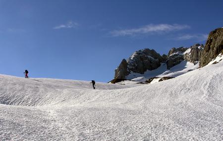
In Pan del Carmen, the hike begins towards the Vegarredonda shelter along the wide dirt track heading uphill between beech trees
Pandecarmen is located very close to Pozo del Alemán, where a dirt track comes together from the crossroads of Les Veleres (kilometre 12 of the CO-4 Covadonga-Los Lagos road). From Pandecarmen we start the route towards the vicinity of the Vegarredonda refuge along the wide dirt track that climbs through beech trees.
In Pan del Carmen, the hike begins towards the Vegarredonda shelter along the wide dirt track heading uphill between beech trees after crossing the bridge over the Pomperi Stream. The hike continues between mountain meadows and stone huts towards Collada Gamonal col (1,450 m) from where you can see a skyline traced by the outline of El Cornión Range. You then reach the Vegarredonda shelter, at 1,500 m, where you can fill your canteens.
The hike continues to Ordiales Scenic Balcony, taking the path to the left that runs southward past the old shelter and through the succession of fields to be found from Cuerri Benita to Llampa Cimera. You then come to another fork in the track with a yellow marking on a stone, indicating that you need to continue the hike to La Mazada (2,040 m). El Requexón, La Torrezuela and Enmedio rise up nearby.
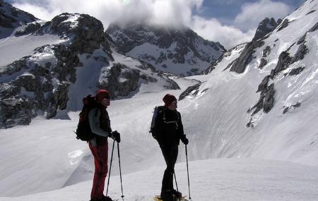
The path heads eastward below Las Cebolladas and above the Prieta spring crowning the great Jou Lluengu cirque. The Park path ends here. A path marked with "jitos" (cairns) -small piles of stones used by mountaineers to indicate the path- continues further eastward towards Vega Huerta. You then start the not too pleasant climb up through the scree that leads to the summit of the saddle known as Horcada de Santa María (2.360 m).
From this peculiar balcony, you can peer into the Jou Santu cirque surrounded by jagged peaks. Torre de Santa María is northeast of where you currently are, so you now take the normal route of ascent which starts a few metres below. You have to climb a ridge and then steadily ascend Peña Rubia crevasse, which you climb diagonally until reaching the summit gap. You then head slightly downhill to the north face, where you continue along a marked gully leading to the summit (2,478 m). As a reward for your efforts, you can enjoy the most rugged landscape in southern Europe in all its magnitude.
Pandecarmen - Torre de Santa María 8
From Pandecarmen we start the route towards the vicinity of the Vegarredonda refuge (Cangas de Onís) along the wide dirt track that climbs through beech trees, after crossing the bridge over the Pomperi stream. The route continues between meadows and huts towards Gamonal pass (1,450 m.) from where we can see the horizon outlined by the reliefs of the Cornión mountains. We arrive at the Vegarredonda refuge, at 1,500 m, where we will stock up on water.
We resume our walk towards the Ordiales viewpoint, taking the path on the left to the south, which passes next to the old refuge and crosses the successive paths that we find from Cuerri Benita to Llampa Cimera. We find another fork in the path with a yellow sign on a stone indicating that we should continue the route towards La Mazada (2,040 m.). El Requexón, La Torrezuela and Enmedio loom nearby.
The path turns eastwards below the Cebolladas and above the Fuente Prieta fountain that crowns the large hollow of Jou Lluengu. This is the end of the Park's path. A path marked with "jitos" - small piles of stones used by mountaineers to indicate the way - continues further east in the direction of Vega Huerta. We will take the annoying ascent along the rocky slopes that takes us to the top of the Horcada de Santa María (2,360 m.).
From this peculiar balcony we look out over the hollow of Jou Santu surrounded by sharp needles. The Torre de Santa María is situated to the northeast of our situation where we link up with the normal ascent route that starts a few metres further down. We have to climb up a ledge and then steadily climb up the Peña Rubia crevasse where we climb diagonally until we reach the summit gap. We descend slightly towards the north face, where we continue along a marked corridor that leaves us at the summit (2,478 m). As a reward for our effort we will enjoy the magnitude of the most rugged landscape in Southern Europe.