

Stage 13: Campumanes - Chanuces
- Lena and Quirós Asturias Centre
- Distance: 25,4 kms
- Difficulty: High
- Code: GR109 Asturias Interior - Stage 13
- Altitude: 1.386,99 m.
- Unevenness: 1.372 m.
-
On foot:
8 h. 30 min.
Only one way
- Start point: Campumanes
- Tour type: Crossing
- Layout of the route: Download kml

Info
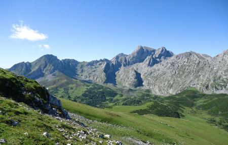
Starting from the council of Lena, in the village of Campumanes, the Nature Trail runs northwest to the council of Quirós, to the rural village of Chanuces, along a route that runs mostly along the border of both councils and overlooks the surrounding mountains and forests, offering magnificent panoramic views.
Route
Campumanes - Chanuces 25,4
The first section of this stage starts in the village of Campumanes, in the council of Lena. Following the directional signs, the route crosses the village, leaves the church of Nuestra Señora de las Nieves on the left, passes under the A-66 motorway and joins the LE-8 road, which runs along the valley of the river Huerna, towards the rural village of Zureda.
The route then continues along the road. At Sotiello, the route turns to the right, passes through this village and continues parallel to the river Teso until it reaches the rural village of Zureda. The path then continues ascending, between meadows and copses of leafy trees, until it reaches the hamlet of El Vache or El Valle, where it leaves the road and joins a gravel track that turns off to the left, before the bridge over the river Zureda.
Continuing the ascent up the hillside, between thickets of bushes and ferns, we will reach the Mayáu (mayéu or majada) La Gallina, where we will find a thematic table that interprets the panoramic views of the area towards Las Ubiñas, Peña Rueda, the Agüeria passes and Los Fontanes.
Afterwards, once we reach the Mayáu de La Balsa, we start to descend slightly through beech(Fagus sylvatica) and holly(Ilex aquifolium) woods, until we reach the Mayáu de La Felguera, occupied by pastureland, from where we can enjoy beautiful views of the beech forests that dominate El Mofoso mountain.
A few metres from the Mayáu de La Felguera, the route descends moderately and leaves the mountain track to turn off to the right onto the QU 5 road, in the direction of the Alto de La Corredoria. At this point, the Nature Trail continues turning left along the road, towards the rural village of Chanuces, located in the municipality of Quirós, and the end of the stage. On this last stretch to Llanuces, we will find a rest area and a viewpoint on the left-hand side of the road, where we can rest and enjoy the views before reaching our destination.
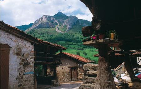
In Llanuces we can visit the Palace of the Miranda family, built in the 16th century and later renovated. The façade is emblazoned with coats of arms and has a pointed entrance door at one end. The building, with a rectangular floor plan, has two floors adapted to the unevenness of the terrain and has a regular layout of the openings. It also has a series of adjoining rooms, such as the keepers' house, the granary, the stables and a chapel with the image of the Virgen de la Candelaria inside (14th century).