
From the canal to the sea
- Avilés, Illas, Corvera de Asturias and Castrillón Asturias Centre
- Distance: 46,2 kms
- Difficulty: Half
- Altitude: 203.46 (maximum)
- Unevenness: 796.96 (rising) m.
- Mountain bike: 1 day
- Start point: Avilés
- Tour type: Circular
- Layout of the route: Download kml
Info
The route starts in Avilés, taking the cycle path along the estuary to the old Ensidesa Hospitalillo. From there it continues along the Arlós river path, passing through Llaranes and Villalegre, and reaches Molleda, where the Senda Verde del Agua starts, present in several sections of the route.
It is a route that combines rural inland and coastal areas, so it is not recommended for road bikes. Extreme caution should be exercised on the general road sections, as well as on wooden footbridges and bridges (they can be slippery) and in areas of sand, loose stones, slopes or leaves.
Route
Avilés - Avilés
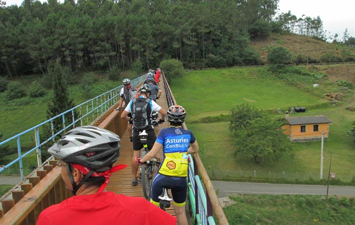
The Green Water Trail, which crosses the municipalities of Corvera, Illas and Castrillón, consists of two sections: Molleda-Pillarno and Pillarno-Soto del Barco. This path runs parallel to the Narcea canal, an infrastructure built around 1950 by the then ENSIDESA (Empresa Nacional Siderúrgica Sociedad Anónima) to supply water, connecting the Narcea river in Quinzanas (Pravia) with the Trasona reservoir (Corvera). The path allows you to see some of the aqueducts, tunnels and siphons of this canal, which stand out for their spectacular nature. In addition, the path passes through several villages and we will see the emblematic Gorfolí peak (the one with the antennas) on our left.
In Molleda we take the first section of the path towards Pillarno, where we can stop to recharge our batteries. From Pillarno we take the second section of the path towards the town of Soto del Barco, but we do not enter it, as we have to turn off at the village of Corrada to reach the Alto del Praviano. A refreshment stop can be made there.
From the Alto del Praviano, you pass through an area of paths (caution) that leads to Santiago del Monte where you take the CT-1 road, which after passing through villages such as Naveces, leads to Santa María del Mar, a town known for its black beach. At the end of the beach, the last climb of the route begins, which is approximately 1 km long. The route continues towards Arnao, where you can visit the Arnao Mine Museum. This mining heritage site contains the oldest coal mine in the Iberian Peninsula, the oldest vertical shaft in Asturias and the only underwater mine in Europe.
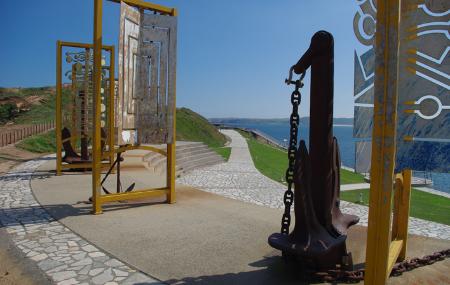
From Arnao the route continues to Salinas. There it is possible to visit the"Museo de las Anclas", conceived as an open-air monumental complex, where the beauty of the anchors stands out, which together with the Temple of the Oceans and the bust of Philippe Cousteau, provide added interest to "La Peñona". This museum is an original creation to pay a continued tribute to the love of the sea, its people and all that it represents.
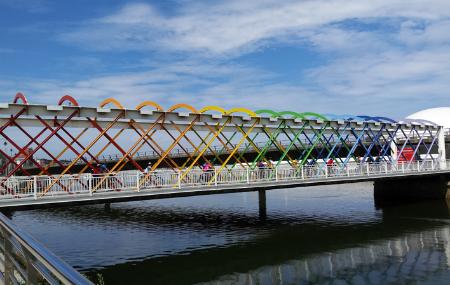
We continue towards Avilés along the Salinas-San Juan path and then cross the port area to see the Avilés estuary promenade, which is forbidden for bicycles, so we have to go along the right-hand side of the river. This leads to the final destination, Avilés, where the town centre is located on one side of the estuary and, on the other, the Niemeyer Centre, which can be reached via "La grapa" and the "Puente de colores" (Bridge of Colours).