
- Vegadeo, San Tirso de Abres, Valdés, Tineo, Cudillero, Pravia, Salas, Oviedo, Riosa, Luanco, Colunga, Piloña, Caravia, Ponga, Ribadesella, Llanes, Ribadedeva, Peñamellera Alta, Peñamellera Baja From west to east
- Distance: 266 kms
- Cars: 7 days
- Start point: Vegadeo
- Layout of the route: Download kml
Asturias is ideal for combining seaside and mountain trips due to the proximity between the two.


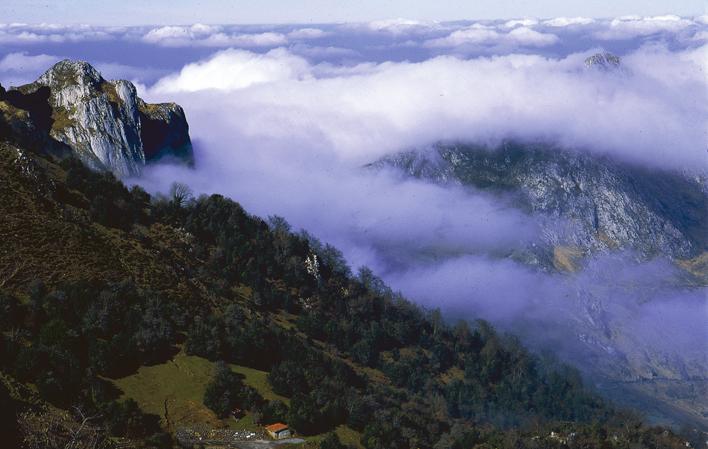
The overwhelming proximity of the mountains to the sea, which gives shape to the Asturian landscape, culminates in the east of the region, where just 20 kilometres separate the Picos de Europa from the coast. The Principality of Asturias is an ideal region for combining seaside and mountain trips, with rivers linking up the two settings. You can enjoy hiking trails and beaches in summer or tour the coastline and discover the region's heritage in winter.
Day 1: Vegadeo - San Tirso de Abres - Playa de Barayo 73,6
Day 1: The tour starts in the west. The starting point on the first day is Vegadeo, a town halfway between the sea and the mountains, where you can visit the Church of Our Lady of the Assumption, the emblematic Town Hall building, located in a 19th-century urban expansion area, and the House of Elisa and Luis Villamil, which accommodates the town's cultural centre. In the neighbourhood of Abres can be found Miranda Mansion, built in the 18th century on the site of an earlier construction. The former Monastery of San Esteban de Piantón was already documented in 1079, although the oldest remains still standing today date from the 16th century. Leaving Vegadeo behind, you can head for San Tirso de Abres on the N-640 to visit the River Eo Fishing Interpretation Centre, located on the first floor of the former training centre founded by emigrants in Havana. San Tirso is an ideal spot to get to know the setting thanks to the 12-km Eo Riverside Path (a greenway that runs along an old railroad), or the Pena do Encanto Route, where, according to legend, an enchanted lady with a silver comb comes out of the rock every Midsummer's Eve. From San Tirso, you head for the unquestionable charm of the coast of this borough which boasts Nature Reserves like that of Barayo, which you can enjoy on the second day of the tour.
Day 2: Playa de Barayo - Luarca - Navelgas 44,5
Day 2: A quick foray into the land of the vaqueiros (nomadic mountain herdsmen) deserves at least a day, driving along the roads linking Valdés and Tineo. Some of the most beautiful beaches in the Asturias can be found on this coastline, including Barayo Nature Reserve, which borders Navia, and the beaches at Otur, Cadavedo and Cueva, which boast all the necessary amenities. And also a town like Luarca, where the harbour, beaches, cemetery, lighthouse, the Mariners Guild Table, the "kissing bridge", the old quarter and the Indiano villas built by returning emigrants who had made their fortune in the Americas make up an ideal setting for a stroll that will allow you to enjoy the town's maritime atmosphere. From this fishing town, the AS-219 towards Pola de Allande takes you to the brañas, mountain meadows dotted with herdsmen's dwellings, among which is that of Aristébano, famous for its vaqueiros weddings. Twenty-two kilometres from Luarca can be found the Vaqueiro Museum, which explains this culture marked by nomadic herding of livestock. The museum is divided into two parts, the first being located in the neighbourhood of Barzanietxa, west of the village of Navaral. The second is situated in Folgueras del Río. These facilities are complemented by four organized routes around the seven brañasin the area. Information on these routes is available at the museum. Less than five kilometres away, the Gold Museum in Navelgas brings this long day to a close.
Day 3: Navelgas - Cudillero - Pravia - Salas 111
Day 3: The day begins on the El Silencio Beach, also known as Gavieiru or Gavieiro Beach, in Castañeras, sixteen kilometres west of Cudillero. You have to park the car in a small authorized area and continue on foot for about ten minutes. The fishing town of Cudillero, one of the most unique in the region, is well worth a visit. This tour can also be a good excuse to become acquainted with traditional salmon fishing. Less than half-an-hour drive along the Autovía del Cantábrico dual carriageway (A-8) brings you to Pravia and the Salmon House, which offers free guided tours but is only open prior advance booking. The Salmon Trail is nearby, in Cornellana (borough of Salas), providing an ideal way to become acquainted with this environment. This flat, 11-km trail links Cornellana and Barcena. There is also a 14-km round-trip hiking trail from Cornellana to Puente de Quinzanas. The borough capital, Salas, is nearby. The old quarter of this medieval town, which was very important on the Way of St James, preserves architectural "gems" such as the Collegiate Church and Valdés Salas Castle, birthplace of the founder of the University of Oviedo, Fernando Valdés Salas. To sweeten the stroll into the past, nothing better than a rich local confectionery made from hazelnuts called "carajitos del professor" .
Day 4: Salas - Oviedo - Riosa 89,5
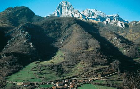
Day 4: The Aramo Range Protected Landscape casts its shadow over Oviedo, constituting a green southern border for the metropolitan area of central Asturias. Three peaks stand out on the horizon at over 1,500 metres: El Gamoniteiru, La Gamonal and El Barriscal. The summit of El Angliru, which can be reached by car (N-630 towards Mieres, and then the AS-231 towards Riosa), is a good starting point for organising a hike. Those willing to travel a little further can pay a visit to one of the two Asturian ski resorts: Valgrande-Pajares (60 kilometres from Oviedo) or Fuentes de Invierno (65 kilometres). In winter you can enjoy the snow and at other times of the year you can get to know the mountains.
Day 5: La Vega - Riofabar 137
Day 5: Colunga and Piloña, two boroughs that are virtually the gateway to the eastern part of the region, are also sea and mountains. Colunga has beaches like La Isla and La Griega, the latter boasting a dinosaur footprints trail. A short distance from there is La Espasa Beach park, a paradise for hikers, surfers and kite flying enthusiasts which belongs to the neighbouring borough of Caravia. You can head inland from the coast via the AS-258 mountain road that ends very near to Infiesto, the borough capital of Piloña. Halfway you can also take a different route, along the AS-358, which crosses the Sueve Range, passes by Borines and ends near Villamayor. In Infiesto, there is the Church of San Antonio and the House of Time and, only one kilometre away on the AS-254, the Shrine of Our Lady of the Cave. If you prefer to head up into the mountains, a good option is La Pesanca Recreational Area. surrounded by woods, it is the starting point for a number of hiking trails. This natural area is accessed via the PL-4, a local road which links up with the N-634 a few kilometres from the borough capital. The route, which follows the course of the River Infierno, takes the traveller into Redes Biosphere Reserve.
Day 6: Riofabar - Ribadesella 110
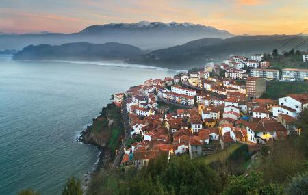
Day 6: East of Piloña there is another lush mountain area to be discovered, conserved by Ponga and its Nature Park. Thirty-seven percent of this territory is forest. The elevation of the terrain ranges from 300 to 2,100 metres above sea level. One of the recommended hiking trails is the Peloño Forest Trail, a path of nearly 25 kilometres in length crossing a territory declared a Partial Nature Reserve, one of its major attractions being an extensive beech wood. You can likewise enjoy nature while practising rafting in Viboli and Carangas canyons, or even canyoning. Just one hour from Ponga (fifty-four kilometres), the Bay of Biscay flows into Ribadesella through its estuary. A walk along Santa María Beach and the harbour to La Guía Chapel reconciles the traveller with the sea.
Day 7: Ribadesella - Alles 75,2
Day 7: The last day heads back in the opposite direction, from the sea breeze to the winds of the Picos. Dotting the coast of Llanes are blowholes, cavities carved into the rock by the sea, which rises to the surface through cracks like chimneys. They amplify the sound of crashing waves. When there is a high tide, they even blow seawater up into the air. The most famous are the Arenillas (one kilometre from Puertas de Vidiago), Santiuste (near Buelna) and Guadamía Blowholes. The journey continues towards Bustio, the last fishing harbour in Asturias, almost on the border with Cantabria, to then take the N-621 road towards Peñamellera Baja. There can be found Buelles Willow Forest, a forest running along the banks of the River Cares between El Mazo, Narganes and Buelles. You can also fish there in season if you have a fishing permit. The last stop is Peñamellera Alta, which retains some of the best fishing preserves in the region, such as Niserias and Rubena. Mountain biking enthusiasts have a unique opportunity to enjoy the route between Mier and La Molinuca. Those who prefer a more leisurely activity can visit the Honey Educational Exhibition, in Alles, a centre devoted to the dissemination of beekeeping.