

Vía de la Plata / Vía Carisa Route
- Lena and Aller Asturias Centre
- Distance: 30,3 kms
- Difficulty: High
- Code: GR100 Vía de la Plata Route - Stage 6 and 7
- Altitude: 466 m.
- Unevenness: 507 m.
-
On foot:
6 h. 30 min.
One way
- Start point: Pendilla de Arbás (León)
- Tour type: Crossing
- Layout of the route: Download kml, Download gpx
Route
Pendilla de Arbás (León) - Carabanzo (Lena) 30
The Carisa was the first and main Roman road in Asturias, and owes its name to Publius Carisius, the legate of Octavian Augustus in 26-22 B.C., who ordered its construction. This mountain road is only a segment of a much longer itinerary, which has only survived to the present day. Justified historical and geographical reasons lead us to situate the headwaters of this road in the present-day cities of León and Gijón, which reached urban status in the Empire.
In this way it linked up with the main land and sea routes of communication in the Empire.
The Carisa Way can be travelled on foot or by mountain bike, as its itinerary is signposted and approved as a GR 100 Vía de la Plata/Vía Carisa long-distance footpath (Stage 7: Carabanzo - Pendilla de Arbás).
The starting point, in a south-north direction, is in the León town of Pendilla de Arbás (municipality of Villamanín), which we will reach by following the N-630 and taking a detour, after passing Busdongo, in the direction of Camplongo de Arbás. Once in Pendilla de Arbás we will find a large car park and the GR information panel, the point from which we will begin our route. We shall continue northwards along a wide track, which leads us along the eastern slope of the Pendilla valley at an even height until we reach the pass of the Propinde pass, where it climbs up to 1,800 metres by means of a system of zigzagging ramps in the place of Las Retuertas.
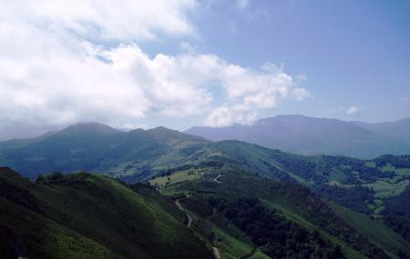
The route then enters Asturian territory, skirting the Tres Concejos/Tresconceyos peak (2014 m), which serves as a natural boundary between the Asturian municipalities of Lena and Aller, and the León municipality of Villamanín, where one of the best remains of the almost 5-metre wide platform is preserved.
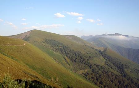
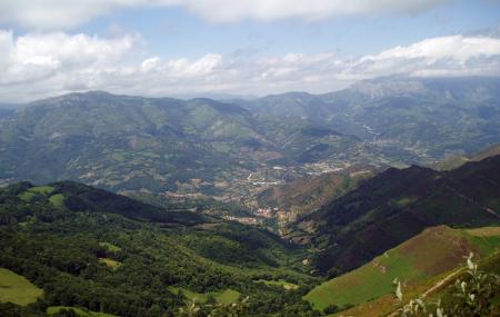
During this route we will enjoy exceptional views thanks to the altitude through which it passes. We continue on a flat path along the Carraceo range, the dividing line between the councils of Aller and Lena, and we will see spectacular panoramic views of the Pajares valley, located on the left, and the Ubiñas mountains in front of us.
At Cruz de Fuentes the route joins the royal road and from here it heads towards Carabanzo, passing the Boya peak (1,728 m), where the Curriechos/Curriel.los Roman camp is located, some 100 metres above the Via Carisa. It is a seasonal camp with approximately 1.5 km of active linear defences, which required a garrison of more than 2,000 men, and an area of 8-9 hectares.
It is one of the highest military settlements in the whole of Hispania and one of the highest in the Empire.
From this point we continue on our way and after barely 1 km we come across the hill of Homón de Faro, where fortifications erected between the 7th and 8th centuries were found, which were probably built to contain the Muslim invasion, and the Cantu Busián, a place where the defensive line ended in a square tower.
We continue on and pass by the Busián sheepfold, La Cava and further on the path forks in two: one variant goes east towards the Acíu pass (1,460 m), where the track connects with the track that goes up from Nembra, on the Allerano slope, and the other to the west via Brañarredonda, on the Lena slope and the original route.
We continue towards Brañarredonda, an itinerary from where we can see the Mayáu Carboneo, already in the village of Congostinas. The two options converge at the Carraceo mayéu (sheepfold). We continue along the mountain range to reach the Espines mayéu (fold), at an altitude of 1,100 m, and continue towards the Las Cruces pass, to finish in the town of Carabanzo (Lena), after having covered almost 30 km of this route.
The Vía Carisa and the transmontane branch of the Silver Route, as well as the archaeological sites of Pico Chagüezos, Monte Curriechos and El Homón de Faro (in the municipalities of Lena and Aller), were declared an Asset of Cultural Interest, with the category of historic route, in October 2017 (Decree 68/2017).