
- Llanes Eastern Asturias
- Distance: 16,2 kms
- Difficulty: High
- Code: GR204 - Coastal Path E9
-
On foot:
4 h. 30 min.
One way
- Start point: Pendueles
- Tour type: Hike
- Layout of the route: Download kml
GR204 - Coastal Path E9 - Stage 2 It can be done on foot or by bicycle.


The starting point is located in Pendueles. Access is via the AS-263 or from the FEVE railway station in Pendueles.
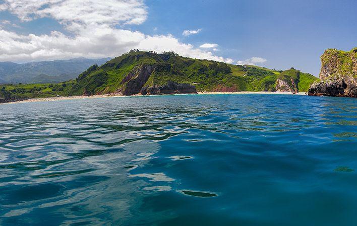
This stretch, the continuation of the Bustio - Pendueles trail, starts out in the centre of the latter village and ends in the town of Llanes, in the vicinity of Toró Beach, and is 13.7 km long.
The trails heads west from the centre of Pendueles. About 100 m on, there is a turning to the right where the trail runs on a flat stretch through meadows for about a kilometre. It then heads sharply downhill for a short time to Novales Stream, which can be crossed via a footbridge. You then skirt the stream until you reach Vidiago Beach.
On this stretch, you can see the remains of an old lime kiln and a prehistoric rock shelter where a shell midden was found. You can also enjoy the lush riverside woodland.
After taking the road to the beach, the trail bears right, following a winding route with short uphill climbs surrounded by meadowland. After about two and a half kilometres, a turning to the right, over the FEVE railway tracks, leads to the village of Vidiago. Scrubland prevails from the fourth kilometre of the trail on, although you can also see oaks, laurels, willows and evergreens.
Some five kilometres into the trail, there is a turning to the right that leads to the village of Puertas de Vidiago. The trail then approaches the coastal cliffs, reaching the Bufones de Arenillas blowholes at km 5.5. This set of twelve seawater blowholes consitutes a natural monument on account of its geological uniqueness. When the sea is rough, you can see the blasts of white sea foam and hear them "roar".
After leaving the cliffs behind, the trail passes through dense plantations of eucalyptus trees until reaching the scenic balcony over the River Purón, from where you can appreciate the beauty of the mouth of this river, a listed Site of Community Importance forming part of the Natura 2000 European network. It boasts outstanding riverside woodland as well as the presence of species of great interest along its course, such as salmon and otters.
The trail crosses the River Purón over a unique plywood footbridge and then heads up a gentle, yet continuous slope until reaching the village of Andrín at km 8.5.
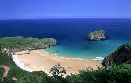
This is an area of beautiful countryside in which woods and meadows alternate with stone walls and luxuriant surrounding vegetation, with an abundance of magnificent holm oak. From Andrín, you can take a detour to visit Andrín Beach, to the east, about 1.2 km away. The trail continues along a widening of the LL-2 road, protected by a wooden balustrade, to La Boriza Scenic Balcony. This offers a beautiful panoramic view of the coastal cliffs and the village of Cué, Ballota Beach and the town of Llanes, against the backdrop of El Cuera Range.
The trail crosses the LL-2 road, around km 9.5, and runs along the north side of Cué Ridge just below the golf course. Around km 13, the trail reaches the Chapel of El Cristo.
Scrubland prevails on the stretch between La Boriza Scenic Balcony and the Chapel of El Cristo and, although the start and end points are at approximately the same elevation, there are a number of steep slopes. The trail offers a detailed view of Toró and Cué Beaches and the spectacular "Cubes of Memory".
It then heads downhill through an oak, chestnut, ash and maple wood to the secondary road that leads to the junction with the LL-2, in the town of Llanes, which is where the sign indicating the end of the trail is located, although it contunes to be signposted to Toró Beach.
Pendueles - Llanes 16
The starting point is in Pendueles. Access is via the AS-263 road or from the Pendueles FEVE station.
The section, a continuation of the Bustio - Pendueles section, starts in the centre of Pendueles and ends in the town of Llanes, in the vicinity of Toró beach, and is 13.7 km long.
The path starts in the centre of Pendueles and heads west. After about 100 m it turns off to the right, running along a flat stretch through meadows until kilometre one. Then there is a steep but short downhill slope to the Novales stream, which is crossed by a footbridge, and then skirts it until it reaches the beach at Vidiago.
In this section you can see the remains of an old lime kiln, and a prehistoric shelter in which a shell pit was found. You can also see lush riverside trees.
After taking the access road to the beach, the path turns off to the right, following a winding route with small slopes, through meadows. At around kilometre two and a half kilometres, a turning to the right, on the FEVE railway line, leads to the village of Vidiago. From kilometre 4 onwards, scrubland predominates, although holm oaks, laurels, willows and evergreens can also be seen.
At around kilometre five, there is a turning to the right that leads to the village of Puertas de Vidiago. The path then approaches the coastal cliffs, reaching the Bufones de Arenillas at kilometre five and a half, a group of twelve buffoons declared a natural monument due to their geological singularity. With the sea alive, you can see their white foam fumaroles and hear their snorting sounds.
After leaving the cliffs, the path crosses dense eucalyptus plantations until it reaches the viewpoint over the river Purón, from where you can appreciate the beauty of its mouth, designated a site of Community importance to form part of the European Natura 2000 network. Its riverside woodland and the presence of species of great interest along its course, such as the salmon and the otter, stand out.
The river Purón is crossed by a unique laminated wooden footbridge, and then ascends a slight and continuous slope to the village of Andrín, at kilometre eight and a half.
There is a beautiful rural landscape with woods and meadows alternating with stone enclosures and abundant vegetation on the edges, including magnificent examples of holm oak. From Andrín you can take the turn-off to the beach of Andrín, to the east, some 1,200 m away. The path continues along a wide stretch of the LL-2 road, protected by a wooden balustrade, until it reaches the La Boriza viewpoint. From here there is an extraordinary view of the coastal cliffs and the village of Cue, Ballota beach and the town of Llanes, with the Cuera mountain range in the background.
The path crosses the LL-2 road at around kilometre nine and a half, and runs along the northern slope of La Cuesta de Cue, just below the golf course. At around kilometre thirteen we reach La Capilla del Cristo.
The Mirador de La Boriza - Capilla de El Cristo section is dominated by scrubland and, although the starting and finishing points are at approximately the same altitude, there are steep slopes. There is a detailed view of the beaches of Toró and Cue and the spectacular "Cubos de la Memoria" (Memory Cubes).
Descend through a forest of oak, chestnut, ash and maple trees until you reach the local road that leads to the junction with the LL-2 road, in the centre of Llanes, and where the signpost indicating the end of the path is located, although it is signposted to Toró beach.