

- Belmonte de Miranda Asturias Centre
- Distance: 13 kms
- Difficulty: Short
- Code: GR109
- Altitude: 827,54
- On foot: 4 h. 30 min.
- Start point: Dolia
- Tour type: Crossing
- Layout of the route: Download kml
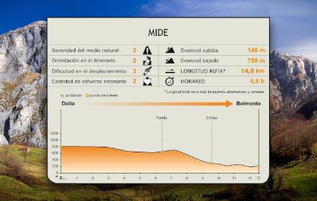
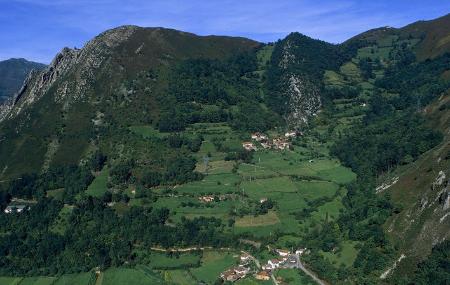
Starting in the town of Dolia, the stage coincides with the Camino Real de La Mesa and, without leaving the council of Belmonte de Miranda, first runs along the northern part of the Sierra de Meruja, before turning south-west in the last section and descending towards the valley of the river Pigüeña, until it reaches the town of Belmonte.
Dolia - Belmonte/Balmonte 13
The first part of the stage coincides with the GR-101 path, the Camino Real de La Mesa, one of the first historic Asturian paths or trails, already used by pre-Romans and Romans. The so-called Camín de La Mesa entered Asturias from León via Torrestío and climbed up the La Mesa pass, reaching San Lorenzo and Dolia, where the route begins.
The first section of the stage runs northwards along the road through the Sierra de Meruja mountain range. In this first section we can see, to the left of the Nature Trail, the wind farm over the Sierra de Begega and, further on, the pastures and cabins over the valley of the river Pigüeña, with the Sierra de la Manteca in the background. The asphalted track goes slightly uphill at first, and then descends slightly towards Las Cruces, where we turn left, following the road until we take the one that leads to Faéu or Faedo.
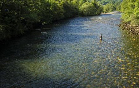
From Faéu we continue along a concrete track until we take a dirt track on the left that descends steeply. At this part of the path we will already see Belmonte, on the left of the route. The hard descent along the track gives way to a path that crosses a forest of carvayos(Quercus robur) and chestnut trees(Castanea sativa), and which, after crossing a stream, will lead us to the rural centre of Corias de Arriba.
From Corias de Arriba, the route continues along the road, reaching Corias de Abajo shortly afterwards, where the route turns to the left, going up a small concrete path, to take a narrow path that leads to Belmonte. In this last section we must take extreme precautions.
Alternative route 1,8
Another option for reaching Belmonte is to continue along the alternative route signposted at Corias de Abajo, which descends along an asphalted track and crosses the river Pigüeña, coming out onto the AS-227 road. The last few metres of this alternative are along the road in the direction of Belmonte, where the end of the stage sign is located next to the road.