

- Aller and Lena Asturias Centre
- Distance: 25,51 kms
- Difficulty: Half
- Code: GR109 - Inland Asturias
- On foot: 8 h. 30 min.
- Start point: Santibanes de Murias
- Tour type: Crossing
- Layout of the route: Download kml
GR109 - Inland Asturias - Stage 12
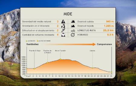

From the council of Aller, towards the southwest, the route crosses the meadows of the Puertos de El Rasón and reaches the Alto de El Tunelón, where it begins a descent towards the council of Lena, following the Roman road of La Carisa for a stretch. After skirting the mountains, the route reaches the town of Campomanes, a crossroads and witness to the pilgrimages to Santiago de Compostela.
Santibanes de Murias - Campumanes 25,51
Starting the route in the village of Santibáñez de Murias, the route crosses the first part of the village on a concrete track, to then go around it and continue towards the El Beyo bridge, over the La Fresnosa stream. The route crosses the bridge and, following the directional signs, begins to ascend along a gravel track, between meadows and trees, until it reaches the Ports of El Rasón.
A habitat of cattle and cowboys, the singular beauty of the landscape of El Rasón is dominated by the mowing meadows limited by wooden fences, where the stone huts that serve as shelter for the shepherds and the animal stables alternate with small holly trees(Ilex aquifolium), forming a harmonious whole.
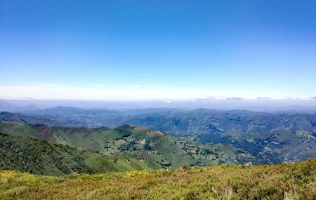
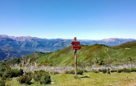
From El Rasón, the route continues ascending moderately, leaving a lake on the right, in the direction of the Alto de El Tunelón, from where we can enjoy magnificent panoramic views. At the Alto de El Tunelón several routes cross, such as the GR AS 100.1 towards Pendilla or towards Carabanzo, so we must pay close attention to the directional signs.
A few metres from the Alto de El Tunelón, approximately one kilometre away, at an altitude of 1,728 metres, is the Roman camp on Mount Curriechos or La Boya peak. For about 3 kilometres, the route follows the Roman road of La Carisa.
Once at El Tunelón, the path continues downhill and then turns to the right, where there is a thematic table interpreting the panoramic views from the area (Las Ubiñas, Peña Rueda, La Cubilla and Los Fontanes mountain passes).
The route then continues around the mountains until it reaches the rural village of Ḷḷinares de Baxo, now in the council of Lena.
After leaving Ḷḷinares, the GR continues along a dirt track that runs over the railway tracks to the rural village of Casorvia.
From Casorvia, the route of the GR continues along an asphalted road in a moderate descent, leaving the village of Malveo on the right, and crosses the river Pajares, before turning right shortly afterwards, until reaching the village of Campomanes, the final destination of the route and where the start-finish of the stage signpost is located.
- Cannot be done with a pushchair/stroller.
- Can be done with mountain bike (high difficulty).