
- Santo Adriano and Quirós Asturias Centre
- Distance: 8 kms
- Difficulty: Short
- Altitude: 551
- Unevenness: 358
-
On foot:
1 h. 30 min
One way
- Geographic situation: Asturias Centre
- Start point: Molín de Las Xanas Recreational Area
- Tour type: One way
- Layout of the route: Download kml, Download gpx
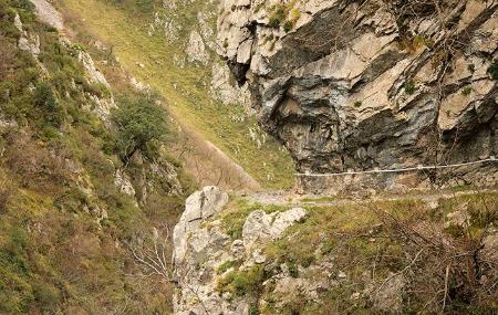
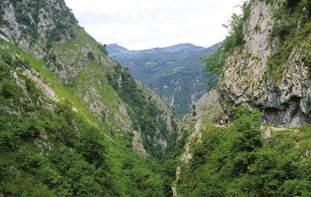

This is one of the best-known routes in Asturias, and with good reason. This gorge opened in the rock by the stream of Las Xanas is a spectacle for the eyes and for the camera, where we can discover, if we look closely, stalactites of ancient caves opened in the limestone and that the river cut leaving them uncovered.
At the bottom of the valley, below our feet, there is a typical riverside forest of which we can only see the tops from the air; above, in the areas where the limestone has almost no earth, in its crevices, it is the holm oaks that barely survive.
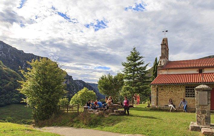
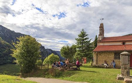
Iron mining left its mark on the area in the form of an old mine, the mouth of which we find in the middle of the route. As we ascend, we leave the gorge behind us and enter the forest, first, and then the green pastures, culminating next to the church of Pedroveya, where we can sit down to eat a sandwich if we do not have a table reserved in the village and enjoy the idyllic landscape.
Molín de Las Xanas Recreation Area (Santo Adriano) - Pedroveya (Quirós) 8
This beautiful and easy out-and-back route runs through Las Xanas gorge, one of the best known and most visited in Asturias. It is a deep crevice located in the vicinity of the Aramo mountain range, at the bottom of which runs the Las Xanas stream.
It begins in the recreational area of Molín de Las Xanas, near the village of Villanueva, where we find a car park where we can leave our car.
About 500 metres from the car park, on the right, there is an explanatory panel that marks the beginning of the path. This is a stone path, dug into the rock face, built in the middle of the last century to connect the villages of Dosango (Santo Adriano) and Pedroveya (Quirós) with the Trubia valley; at some points it is on the edge of the cliff, between 80 and 100 metres above the water.
After approximately 2 kilometres, the surroundings change completely and the path enters a forest, where we can already see the waters of the Las Xanas stream.
We will have walked 3.8 kilometres when we leave the forest and reach a clearing; we are almost at the end of our route. A few metres ahead is Pedroveya, with its beautiful church of San Antonio, and if we turn around and look at the landscape, we can see the entire path of the gorge that we walked through.
The way back is via the same route in the opposite direction, although there is also the possibility of returning via the Valdolayés route, but for this you have to go up to the village of Dosango.