Goldweg

- San Antolin de Ibias, Cecos Westasturien
- Distanz: 8,14 kms
- Schwierigkeit: Mittel
- Kumulierter Höhenunterschied: +383 m
- Kumulierter Höhenunterschied: -383 m
- Maximale Höhe: 595 m
- Mindesthöhe: 262 m
- PPI-Index: 57
- Modus: Wanderer
- Art der Rundfahrt: Rundweg
- Routentyp: Berge
- Rückfahrt mit der Bahn: Nein
Natur, Erinnerung und ländliche Schönheit verschmelzen auf dieser ruhigen Route, die in San Antolín de Ibias beginnt und endet.
Der Goldweg führt durch einige der repräsentativsten Landschaften des Ibias-Tals und verbindet Natur, Archäologie und traditionelle Kultur. Sein Name ist kein Zufall: Es waren die Römer, die auf ihrer unermüdlichen Suche nach Gold in den nordwestlichen Gebieten der Halbinsel das Relief dieser Gegend veränderten und als Erbe alte Bergbaugebiete hinterließen, die wir heute bei einem Spaziergang entlang dieser friedlichen Route entdecken können.
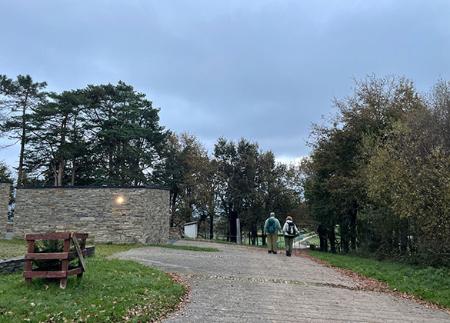
Die Route beginnt in San Antolín de Ibias, neben der Kirche Santa María, ganz in der Nähe des Informationszentrums Palloza. Von hier aus überquert ein Weg den Ibias-Fluss über eine Brücke und verläuft in den ersten Abschnitten parallel zu seinem Lauf, zwischen Wiesen, Heideflächen und Weinbergen, die die landwirtschaftliche Nutzung der Hänge verraten. In der Gegend von El Trigal können wir die alten Weinbergterrassen sehen, die uns von der traditionellen Bewirtschaftung des steilen Geländes erzählen, das heute zum Teil für die Herstellung des Weins Tierra de Cangas genutzt wird, den man sich mit der Nachbargemeinde Allande teilt.
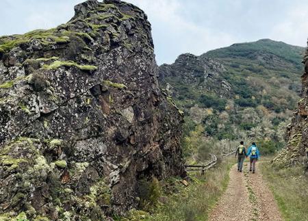
Der Anstieg ist sanft und progressiv, bis er einen höheren Punkt erreicht, von dem aus es über eine rustikale Treppe hinunter zu einer Holzbrücke geht. Auf der anderen Seite führt der Weg in der Nähe des Flusses weiter, begleitet vom Gesang der Amseln, die in den Tümpeln und Bächen leben. An diesem Flussabschnitt liegt der Weiler La Pena'l Corvo, ein perfekt erhaltener ethnografischer Komplex, der ein Haus, einen Getreidespeicher, eine Mühle, einen Stall und eine kleine Kapelle umfasst und ein Beispiel für die traditionelle Lebensweise in Ibias darstellt.
An dieser Stelle bietet die Route einen Abstecher in das Dorf Cecos, das als Pueblo Mágico de España (Magisches Dorf Spaniens) anerkannt ist. Dieses Dorf bewahrt eine bemerkenswerte Schieferarchitektur und eine bezaubernde Kirche und bietet dem Wanderer ein authentisches Erlebnis des ländlichen Lebens. Nach der Rückkehr zur Hauptkreuzung beginnt der Aufstieg nach Villamayor, der im Schatten der Kastanienbäume verläuft, die sich im Herbst golden färben. Wenn man an Höhe gewinnt, kann man die Überreste der alten römischen Goldlagerstätten sehen, die wahren stillen Protagonisten dieser Route.
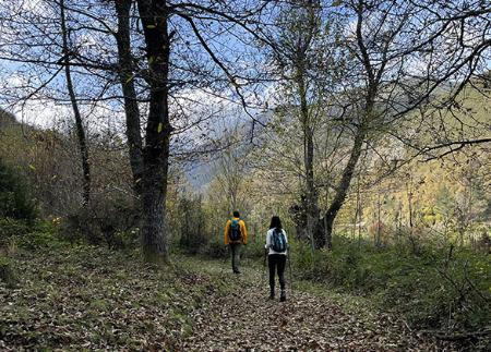
Villamayor erhebt sich mit seinen Schieferhäusern und Schrägdächern, ein Dorf, das in der Landschaft über dem Ibias-Tal thront. Von hier aus geht es wieder bergab durch Weinberge und Wiesen, wobei man weite Ausblicke auf das Tal hat und Bauwerke wie die "Cortines" (Trockenmauern zum Schutz der Bienenstöcke vor Bären) bewundern kann, die für die traditionelle Bienenzucht in dieser Gegend von großer Bedeutung sind.
Der letzte Teil des Weges führt uns durch Kastanienwälder, bis wir nach San Antolín de Ibias zurückkehren und einen Rundweg von geringem Schwierigkeitsgrad und großem Interpretationswert abschließen. Der Goldweg ist viel mehr als ein Spaziergang: Er ist eine Reise durch die römische Bergbaugeschichte, durch das bäuerliche Erbe und durch die Landschaften, die noch heute das ländliche Leben in dieser Gemeinde an der Grenze zu Galicien erhalten.
- Diese Route deckt sich teilweise mit der PR-AS 306, der PR-AS 24 und der GR 203.
Grundlegende Tipps, bevor Sie ins Gebirge gehen
- Wenn Sie mit einem Hund unterwegs sind, nehmen Sie ihn immer an die Leine.
- Vermeiden Sie die Annäherung an das Vieh.
- Wenn Sie auf Doggen treffen, die das Vieh schützen, nähern Sie sich ihnen nicht, streicheln Sie sie nicht und füttern Sie sie nicht. Erlauben Sie ihnen nicht, Ihnen zu folgen oder sich von ihrer Herde zu entfernen. Sie arbeiten.
- Hinterlassen Sie keine Spuren. Sammeln Sie alle Ihre Abfälle, auch die organischen. Die Natur ist keine Müllhalde.
- Handeln Sie mit Bedacht. Planen Sie Ihre Route gut, nehmen Sie alles mit, was Sie brauchen, und achten Sie darauf, dass sie an Ihre körperliche Leistungsfähigkeit angepasst ist.