

- Villayón Western Asturias
- Distance: 4,6 kms
- Difficulty: Short
- Altitude: 371
- Unevenness: 284
- On foot: 1 h. 30 min.
- Start point: Ponticiella (Villayón)
- Tour type: Round trip
- Layout of the route: Download kml, Download gpx

A perfect way to complete the visit to the Cascadas de Oneta is to also approach the nearby Cascadas de Méxica, just 17 kilometres away.
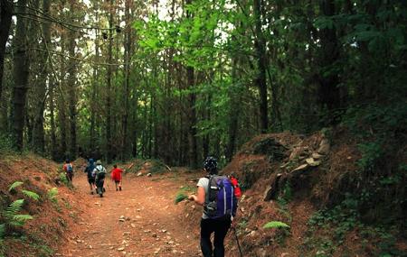
From the village of Ponticiella, we set off down the hillside between houses, vegetable gardens and pastures in search of the waterfall. Along the way, we can't help but enjoy the nature that comes our way, partly natural, partly human intervention, as is the case of the pine plantations that appear frequently throughout the descent.
Among the natural, the strawberry tree, producer of the attractive and alcoholic red fruits called borrachinos, with a certain toxicity if we eat too many; the curious and stinking mushroom Phallus impudicus, which can be seen here, and, without a doubt, the birch, the most frequent natural tree, especially in the lower area closest to the waterfall.
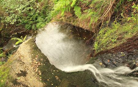
And at the end of it all is her, Méxica, a narrow waterfall pouring directly into a pool of about two metres in diameter right at our feet with almost no room for more and in the middle of the forest. It is certainly worth going down to see it.
Ponticiella - Mexico Waterfall 4,6
This route starts in the village of Ponticiella, where we find a fountain and, right in front of it, the sign for the start of the local path, which runs in a westerly direction to the Cascada de Méxica waterfall.
Once we go down through the houses of the village and leave it, we come to a good, wide, downhill path; in the next 300 metres, we find several detours, but we should not take any of them.
After just 2.3 kilometres, you can already hear the sound of falling water, and you soon reach the Cascada de Méxica, the end of our route.