

Picos de Europa National Park
- Amieva, Cabrales, Cangas de Onís, Onís y Peñamellera Baja Eastern Asturias
- Extension: 646 km 2
- Maximum elevation: 2,648 m. in Torrecerredo (central massif)
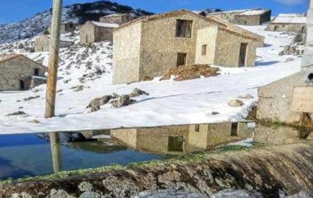
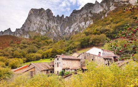
Images


What to see
- Guided tours in the Picos de Europa National Park (01/07 to 30/09, Monday to Friday, except 25/07, 15/08 and 08/09). Information andbookingsOpens in a new tab.
- Visitor Reception Centre, Casa Dago (Cangas de Onís).
- Visitor Centre Pedro Pidal Lagos de Covadonga (Cangas de Onís).
- Cueva-Exposición del Quesu (Cheese Cave-Exhibition) and artisan production centres for Cabrales Cheese (PDO) (Cabrales).
- Routes: Cares (Cabrales), Entrelagos (Cangas de Onís), Panes-Alles (Peñamellera Alta and Peñamellera Baja).
- Protected areas within the Park: Torca de Urriellu Natural Monuments (Cabrales), Trave System (Cabrales), Jitu System (Onís), Toneyu Network (Amieva).
- Flora and fauna observation: golden eagle, chamois, beech.
- Royal Site of Covadonga (Cangas de Onís).
- Covadonga Lakes(Ercina and Enol) (Cangas de Onís).
- Majada de Belbín (Onís).
- Bulnes and its funicular railwaybookingsOpens in a new tab (Cabrales).
- What should I know before visiting the Picos de Europa National Park?bookingsOpens in a new tab
- This is what the Picos de Europa sound likebookingsOpens in a new tab.
Info
In the Picos de Europa National Park all types of pets must be properly controlled by their owner (on a leash), except for herd guardians and guide dogs, as the National Park is a special hunting area and, given the abundance of livestock at certain times of the year, any disturbance to livestock must be avoided.
Regulations on pets in the Picos de Europa National Park (opens in a new tab
Different folding and glaciations have shaped a tortuous landscape modelled by ice and the effect of the waters on the limestone, forming a grandiose mountain karst. The three main massifs of this natural wonder are limited by deep valleys and gorges, formed by the erosive passage of the sharp tongues of ice of the glaciers and the force of the waters of the rivers that, even today, continue to shape the stone to their liking, dissolving the limestone.
The Picos de Europa Biosphere Reserve and National Park of the same name was declared a Biosphere Reserve in 2003 and is made up of the municipalities of Amieva, Cabrales, Cangas de Onís, Onís and Peñamellera Baja. There is a small area in the municipality of Peñamellera Alta that is also part of the National Park , although not part of the Biosphere Reserve, because the extension of the National Park came after the declaration of the Biosphere Reserve.
The rivers Dobra, a tributary of the Sella, and Deva flank the mountains to the west and east of the range, with the Cares and its tributary the Duje distributing the park into its three massifs.

In the Central Massif we find the highest peaks of the Cantabrian Mountains in the steep Urrieles, where the most emblematic landmark of the Picos de Europa rises: the immense beauty of the Picu Urriellu or Naranjo de Bulnes. Its 2,519 metres of complicated orography have not prevented human settlement, and the village of Bulnes is famous. Until 2001, it was only accessible by a narrow and steep path in the mountain. Since then, access has become easier thanks to the funicular railway that crosses the mountain from the village of Poncebos.
To the east of the Urrieles is the eastern massif, the Ándara, the smallest with a more gentle profile, whose highest peak is at Morra de Lechugales at an altitude of 2,400 metres. The westernmost of the three massifs is the Picos del Cornión, near the Royal Site of Covadonga, a religious pilgrimage destination for thousands of people every year. There, the lakes Enol and Ercina reflect the lofty mountains where the legendary history of Asturias was born.

In the cave of Covadonga itself you can enjoy the omnipresent trace of the karstic process of the Picos, in the photographic emergence of the Orandi river, under the image of the Virgin. Between the Urrieles and the Cornión, separating the Central and Western massifs from south to north, flows the river Cares, whose crystal-clear waters lash its entire course. Of the beautiful peaks of the Western massif, La Peña Santa de Castilla, at 2,596 metres, stands out. On its way we find the Ordiales Viewpoint, where a drop of almost 1,000 metres falls down to the valley, impressing all who visit it.
Plant life
The landscape of the Picos de Europa is dominated by large rocky areas, especially above 1,500 metres above sea level, and at lower altitudes there are grasslands and scrubland, alternating with wooded areas. At lower altitudes there are pastures and scrubland, alternating with wooded areas, and in the most favourable areas there are beech, oak, mixed forests and holm oak and holm oak woods. There is also a wide variety of mountain flowers which, adapted to extreme conditions, fill the paths to the summits with colour.
The climate is typical of the high mountains: cool temperatures of around 8°C in the mid-mountains and below 0°C on the summits, with abundant rainfall and snow.
Wildlife
The variety of landscapes in the Picos de Europa allows you to see a wide range of fauna. In the mountains it is common to see golden eagles, as well as vultures and Egyptian vultures that nest on rocky walls.
In the forests live roe deer, wild boar and partridges, and in some areas also the capercaillie, although it is not easy to see. In the high, rocky areas it is common to find chamois, especially in spring. Rivers and lakes are home to otters, trout, salmon and Alpine newts, and colonies of bats live in limestone caves. Owls can be seen in sheepfolds and traditional buildings at dusk, when they prepare to go hunting.
Map
Interesting links:
- Application forms for different activities in the Picos de Europa National Park Opens in a new tab
- Lakes Access Plan 2026
CONTACT
Visitor Reception Centre.Dago House
33550 Cangues d'Onís/Cangas de Onís
Telephone 985 848 614
Bulnes Funicular
33554 Poncebos, Cabrales
Telephone 985 846 800